
Solar Kids Course. Complete storm hydrograph in small stream channel. Wegener's Puzzling Evidence Exercise (6th Grade) Although Alfred Wegener was not the first to suggest that continents have moved about the Earth, his presentation of carefully compiled evidence for continental drift inspired decades of scientific debate.
Wegener's evidence, in concert with compelling evidence provided by post World War II technology, eventually led to universal acceptance of the theory of Plate Tectonics in the scientific community. The following files are needed for this exercise and can be downloaded in pdf format (Teacher Overview, (For Teachers) Wegener's Key to Continental Positions for grade 6, Student Puzzle Pieces, Key to Wegener's Evidence sheet, and Student Map of the World Today). If students need additional hints beyond those provided below, there is a Puzzle Outline Hint to be used as a base for the puzzle. Objectives Students will observe and analyze scientific evidence used by Wegener. The Student Puzzle Pieces and Legend To start this activity the teacher will present background information on Wegener. Origins of the Atmosphere. Plate Boundary Overview. Introduction to Earth Science. Earthquakes & Volcanoes - Geography for 2013 & Beyond. How Earthquakes Trigger Tsunamis - Bang Goes The Theory, Preview - BBC One.
Most dangerous job in the world: Incredible footage of men working on top of volcanos. This incredible footage shows men working on a super volcanic mountain range in East Java, Indonesia.
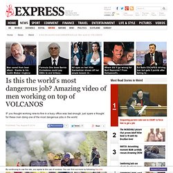
The workers, many of whom aren't expected to live past 50, breathe highly noxious gases which come out of the Kawah Ijen Volcano without masks, carrying loads of up to 70kg on their backs from a quarry. Many work shirtless and have huge growths on their backs from the heavy loads. Photographer Brad Ambrose captured the pictures along with his pal Geoff Mackley, while trekking through Indonesia.
Plate tectonics. Continental Drift and Plate Tectonics. Earth Forces - GeoResource. Earth - The world's most deadly volcanoes. Last August, in southern Iceland, the flanks of the volcano Bardarbunga ripped open and fountains of lava spouted skyward.
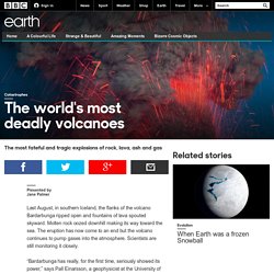
Molten rock oozed downhill making its way toward the sea. The eruption has now come to an end but the volcano continues to pump gases into the atmosphere. Scientists are still monitoring it closely. “Bardarbunga has really, for the first time, seriously showed its power,” says Pall Einarsson, a geophysicist at the University of Iceland. But, for now, the eruption has followed what Einarsson describes as the “best case scenario.” Laki’s eruption started in 1783 and, for eight long months, it spewed lava and noxious gases. But Laki’s devastation spread well beyond the ‘island of fire and ice.’ All the World's Volcano Webcams. Global risks: Pool knowledge to stem losses from disasters. Turjoy Chowdhury/Nurphoto/Corbis This year's deadly earthquakes in Nepal killed more than 8,000 people and reduced thousands of buildings to rubble.
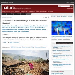
In April and May, two massive earthquakes in Nepal killed more than 8,400 people, injured 20,000 and reduced 300,000 houses to rubble. Water Scarcity. J. Rainforest role in the water cycle « Rainforest Conservation Fund. Freshwater is an essential resource which is under increasing pressure.
Dams and other diversionary activities, particularly agriculture, have diverted a huge amount of the world’s fresh water for human use. Humans now use more than 50% of the available fresh water of the earth, and this proportion is en route to increase to 70% in the next half-century. Therefore it behooves us to attend to all factors which affect the water cycle. Although the role of rainforests in the global water cycle is relatively small compared to that of the oceans, it is nevertheless extremely important. Rainforests influence the hydrologic cycle in the following ways: 1) Precipitation. Liquid Planet - Water Infographic.
Schools - The Water Resource. Delicious Visual Map of History. 40 maps that explain the Roman Empire. By Timothy B.
Lee on August 19, 2014 Two thousand years ago, on August 19, 14 AD, Caesar Augustus died. He was Rome's first emperor, having won a civil war more than 40 years earlier that transformed the dysfunctional Roman Republic into an empire. Under Augustus and his successors, the empire experienced 200 years of relative peace and prosperity. Here are 40 maps that explain the Roman Empire — its rise and fall, its culture and economy, and how it laid the foundations of the modern world. Facing History and Ourselves. Time lapse map of every nuclear explosion ever on Earth. Rising Seas - Interactive: If All The Ice Melted. BBC Animated guides. A Geography quiz for Key Stage 3. The World as 100 People. MapAList - Create and Manage Maps of Address Lists. Journey to the Centre of the Earth.
NatGeo Mapmaker Interactive. History of Western European Russia - Lonely Planet Travel Information. History of Europe between the Two World Wars 1918-1942 : Europe after World War I. Maps of War. History of Europe since 1945 : Europe from one century to another 1990-2005. History of Europe in the 19th century : The Congress of Vienna 1814-1815 (The map as History) 40 Maps That Explain The Middle East. Seventh Grade (Grade 7) World History Questions for Tests and Worksheets. Common Core for Grade 7. Why-study-history-2c3t0vv.jpg (JPEG Image, 398 × 220 pixels) Timeline Of Historical Periods. Stories of Sir John A.