

Internet Watch Foundation. The Internet Watch Foundation (IWF) is a registered charity[2] based in Cambridgeshire, England.
It states that its remit is "to minimise the availability of 'potentially criminal' Internet content, specifically images of child sexual abuse (including child pornography) hosted anywhere, and criminally obscene adult content in the UK". Content inciting racial hatred was removed from the IWF's remit on the setting up of a police website for the purpose in April 2011.[3] The IWF clarifies on its website that potentially criminal activity is addressed, as content can be confirmed to be criminal only by a court of law. As part of its function, the IWF says that it will "supply partners with an accurate and current URL list to enable blocking of child sexual abuse content". The IWF operates in informal partnership with the police, government, public, and Internet service providers.
History[edit] Background[edit] We are being portrayed as a bunch of porn merchants. Foundation of IWF[edit] Maps to be Used for the History of Europe. Periodis Web - A Historical Atlas and Gazetteer of Europe from Year 1 to 2000 Europe in Year 2000 Europe in Year 1900 Europe in Year 1800 Europe in Year 1700 Europe in Year 1600 Europe in Year 1500 Europe in Year 1400 Europe in Year 1300 Europe in Year 1200 Europe in Year 1100 Europe in Year 1000 Europe in Year 900 Europe in Year 800 Europe in Year 700 Europe in Year 600 Europe in Year 500 Europe in Year 400 Europe in Year 300 Europe in Year 200 Europe in Year 100 Europe in Year 1 Detailed Regional Periodis Maps The Aegean Area The Apennine Peninsula The Iberian Peninsula Between Oder and Dnieper Between Pyrenees and Rhine Between Rhine and Oder Between Rhine and Rhône Sequential maps on the same base map of Europe and the Near East, which are facilitating comparison Euratlas Periodis Web shows the history of Europe through a sequence of 21 historical maps, every map depicting the political situation at the end of each century.
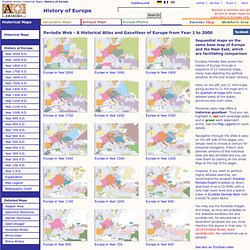
Moreover, each map offers a historical gazetteer. Language Map of Ancient Italy. Language Map of Ancient Italy Abbreviations: Aeq.- Aequian; Aur.- Auruncan; Fal.- Faliscan; Hern.- Hernican; Lat.- Latin; Marr.- Marrucinian; Mars.- Marsian; Nov.- Novilara; Pael.- Paelignian; Vest.- Vestinian; Notes: The lower Po valley (marked off from Etruscan by a dotted line) was colonized by Etruscans from 600-400 B.C. and adopted their language.
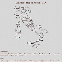
Celtic-speaking Gauls (Senones) then occupied the area until the Roman conquest. Language Map of Ancient Italy. Free Bible Maps of Bible Times and Lands. Free High Resolution Bible Study Maps Copyright and usage notes about this map web site: 1.
We wanted to provide high quality Bible maps that were reproducible by you the seeker! Free Bible Maps of Bible Times and Lands. Macrohistory : World History. Macrohistory : World History. Rome and Romania, Roman Emperors, Byzantine Emperors, etc. Emperors of the Roman and the so-called Byzantine Empires; Princes, Kings, and Tsars of Numidia, Judaea, Bulgaria, Serbia, Wallachia, & Moldavia; and the Sultâns of Rûm Caught in that sensual music all neglect Monuments of unageing intellect.
William Butler Yeats (1865–1939), "Sailing to Byzantium" Rome casts a long shadow. I am writing in the Latin alphabet. Applied to the days of the week. Indeed, the Romans were rather more successful than is usually thought. Rome, but at Constantinople, New Rome, Nova Roma, . , "Great Rome" [De Administrando Imperio, Greek text edited by Gy. Was in fact still the Roman Empire, known to Western Europeans, "Latins" or "Franks" at the time, as Romania, already the name of the Empire in Late Antiquity. . , to mean the ancient pagan Greeks, as the word is used in the New Testament -- sometimes the Latin word for Greeks would be borrowed, as Graikoi, , if this was needed for contemporary reference, as for the language. . , Rhômania, as in Latin. Index Home Page I. Code of Hammurabi.