

GeoAutomation. GeoAutomation portable system with reduced dimensions can easily be used indoors.
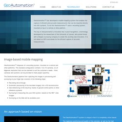
The technology stays the same. Cameras all around give the possibility to view, measure and reconstruct the complete indoor infrastructure. Extra cameras are added to give a better view on the ceiling. The portable system similar to what we use for indoor is also great for mapping parcs, small alleys, bike roads, walkways, sidewalks and all other places not reachable with a vehicle. Tunnels <br/> We work with images, so evidently we need some light to operate. .: Agriculture - Industry - Marine Control Inspection Group :. Lambda Tech International. DAYTIME ROADWAY VIDEO LOG AND QUANTITATIVE ROW ASSET MAPPING. Imajing, mobile surveying and mapping solution.
The Riverview Project. The Riverview Project is the core public outreach and educational program of Below the Surface (BTS).
Riverview was inspired by Google’s Streetview mapping technology and tools, with the intention of creating a platform to visualize, interact with and explore rivers throughout the world. The Riverview Project – Mission Create the leading visual platform to establish baselines and aggregate data on hydrologic structure, function, and changes while illustrating how waterway recreation can enhance the protection of America’s waterways and other natural resources. That along with LIDAR, Multi-beam SONAR, and other parameters to build the most comprehensive database of America’s waterways. The Riverview Project – The Plan Below The Surface recently acquired Immersive Media’s Quattro camera, which consists offour Sony ICX 724 CCD sensors. Our maps will serve as a host for information about paddling and water quality from the mountains to the surf breaks.
Mobile App Coming Soon! The Riverview Project: Creating an Immersive Map of America's Waterways. One of the latest endeavors in the world of 360 degree immersive video comes from an organization called Below The Surface, whose Riverview Project is seeking to create a virtual map of America’s waterways.
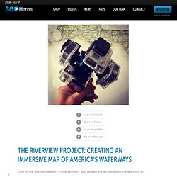
In order to deliver visual information about these rivers to a larger audience, this project is utilizing 360Heros 360 video gear to create an immersive data center. Following a pilot run on the Apalachicola River, the Sacramento River is Riverview’s most recent and more streamlined expedition for this hybrid film and research project. Riverview is the brainchild of Kristian Gustavson, the Director of Research and Explorations for Below the Surface. As an avid surfer and experienced oceanographer, Kristian has witnessed firsthand the pollution emptying from our nation’s rivers into the ocean.
Riverview was born as a medium to raise awareness for waterway conservation via exploration and detailed documentation. © 2011-2014 360Heros™ is a 360Heros Inc Company. Imajing, mobile surveying and mapping solution. WMS rotation support in Geoserver 2.0.2. This is a video composite of geotagged timelapse photos while travelling along the newly opened LKSA highway.
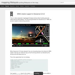
The map was generated from Geoserver 2.0.1 WMS. An arrow is rotated to follow driving direction. When Geoserver 2.0.2 was released it has one interesting feature that allows for WMS rotation. Now we can rotate the map so that the driving direction as indicated by the driving arrow will always point up. This is the original data from my tracklog: <trkpt lat="3.0128709" lon="101.5371921"><ele>19.00</ele><time>2010-05-23T19:32:47Z</time><course>322.73</course><speed>16.69</speed><sat>7</sat><hdop>1.35</hdop><vdop>1.68</vdop></trkpt> Use negative course value for the rotation angle for Geoserver to rotate the WMS in counter-clockwise direction so that the course heading will point up.
GPS tracks & videos synchronized in great 3D GPS player. Your adventure with gpsPlayer begins here ride a bike, a motorcycle, a horse to capture magnificent moment of your life fly the parachute, a wingsuit, a paraglide to know where You have been when the best happened drive a car, a bus, a boat and post Your outdoor events slide on snowboard, ski, sledge online gps + video publishing service.
FARO Europe Blog. The new FARO Focus mobile mapping kit provides access to the technology of mobile mapping for every FARO Focus 3D user.
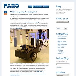
As a low cost do-it-yourself solution, the mobile mapping kit offers an affordable, efficient and precise tool to all users who want to explore the world of mobile mapping. After the first presentation of the do-it-yourself mobile mapping concept at the Faro user meeting in Strasbourg (2013) the development and research has continued and the idea has evolved into a unique solution. The mobile mapping kit uses a cost effective and high precision Applanix AP15 (Inertial Navigation System) and includes a free to use plugin app for FARO SCENE. With the new Helical app it is possible to merge the vehicles trajectory with the helical scan data directly in SCENE. Also calibration procedures have been developed that can be performed easily by the system operator at any time.