

Fresno County Weather Stations Map. The Google Maps Javascript API V3 - Google Maps JavaScript API V3 - Google Code. Maps Javascript API V3 Reference - Google Maps JavaScript API V3 - Google Code. Release Version Last updated Monday, August 05, 2013 This reference documents version 3.14 (the release version) of the Maps Javascript API released February 19, 2013.
This release version of the API is a feature-stable version of the API whose interfaces are guaranteed to remain as documented within these pages until this version is retired. To consult the latest (experimental) version of the Maps Javascript API, see the Experimental Development Reference. Version 3.13 is the last version of the Google Maps JavaScript API that will display legacy styles. Reference Table of Contents Map Controls Overlays Services Map Types Layers Street View Events Base Geometry Library AdSense Library Panoramio Library Places Library Drawing Library Weather Library Visualization Library.
KML Reference - KML - Google Code. This section contains an alphabetical reference for all KML elements defined in KML Version 2.2, as well as elements in the Google extension namespace.
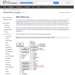
The class tree for KML elements is shown below. In this diagram, elements to the right on a particular branch in the tree are extensions of the elements to their left. For example, Placemark is a special kind of Feature. It contains all of the elements that belong to Feature, and it adds some elements that are specific to the Placemark element. KML is an open standard officially named the OpenGIS® KML Encoding Standard (OGC KML). The complete XML schema for KML is located at Note: Click an element name in this diagram to jump to its entry in the reference section. Note that abstract elements (shown in boxes in the diagram) are not actually used in KML files. All elements derived from Object can have an id assigned to them. Because KML is an XML grammar and file format, tag names are case-sensitive and must appear exactly as shown here. <!
KML Support - KML - Google Code. Display KML on a Google Map - www.thechrisoshow.com. Layers - Google Maps JavaScript API V3 - Google Code. Layers Overview Layers are objects on the map that consist of one or more separate items, but are manipulated as a single unit.
Layers generally reflect collections of objects that you add on top of the map to designate a common association. The Maps API manages the presentation of objects within layers by rendering their constituent items into one object (typically a tile overlay) and displaying them as the map's viewport changes. Layers may also alter the presentation layer of the map itself, slightly altering the base tiles in a fashion consistent with the layer. Note that most layers, by design, may not be accessed via their individual objects, but may only be manipulated as a unit. To add a layer to a map, you only need to call setMap(), passing it the map object on which to display the layer. Overlays - Google Maps JavaScript API V3 - Google Code. The Google Geocoding API - Google Maps API Web Services - Google Code.
This document discusses the Geocoding API v3.
Note that the Geocoding API v2 has been turned down and is no longer available. Users of the Geocoding API v2 service should upgrade to v3. Looking to use this service in a JavaScript application? Check out the Geocoder class of the Google Maps API v3. What is Geocoding? Geocoding is the process of converting addresses (like "1600 Amphitheatre Parkway, Mountain View, CA") into geographic coordinates (like latitude 37.423021 and longitude -122.083739), which you can use to place markers or position the map.
Reverse geocoding is the process of converting geographic coordinates into a human-readable address. The Google Geocoding API provides a direct way to access a these services via an HTTP request. Before You Begin This document is intended for website and mobile developers who want to use geocoding data within maps provided by one of the Google Maps APIs. Geocoding is a time and resource intensive task. API Key Usage Limits. TIGER Data. County Boundary Map. Creating Custom Maps with John Coryat. Index of /ws-2008-02. List of counties in California.
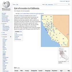
County FIPS code of California List[edit] Defunct counties[edit] See also[edit] Notes[edit] External links[edit]
Untitled. Models, degree-days, and weather - UC Statewide IPM Program. Description for Weather Station CARUTHRS.A.