Resources for Teaching about Volcanoes
Make Your Own Caldera - Teachers. 3 Die in Mammoth Ski Patrol Accident. Three ski patrol members were killed Thursday at Mammoth Mountain ski area when they fell into a geothermal vent that they were working to fence off.

Seven other ski patrollers were injured in the incident. The deaths bring the total this year to eight at the popular Eastern Sierra ski resort, which broke its all-time snowfall record Tuesday. This winter season has been a deadly one for California, with at least 13 skiers dying.
Defusing Africa's Killer Lakes.
ON THE NIGHT OF THE APOCALYPSE, Ephriam Che was in his mud-brick house on a cliff above Nyos, a crater lake in the volcanic highlands of northwest Cameroon.

A half-moon lit the water and the hills and valleys beyond. Around 9 p.m., Che, a subsistence farmer with four children, heard a rumbling that sounded like a rockslide. Then a strange white mist rose from the lake.
USGS: Volcano Hazards Program CalVO Long Valley Caldera. View from Lookout Mountain of Obsidian Dome and surrounding area, Long Valley Caldera.
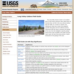
The Long Valley Volcanic Center is an excellent place to learn about volcanoes.
Sir2012 5176 a plate1. USGS: Volcano Hazards Program CalVO Mammoth Mountain. Volcano Hazards Program CalVO Mammoth Mountain. Horseshoe Lake, Mammoth Mountain, California (Google Earth image) with area of elevated carbon dioxide degassing measurements from 2012 in rainbow colors (highest amount in purple to normal in blue).
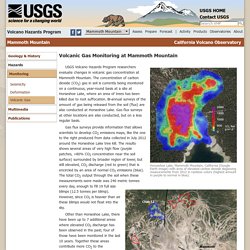
Mammoth Mountain, California (Gooogle Earth image) with elevated carbon dioxide degassing areas (rainbow colors) from 2011-2012 research. Click for further description. USGS Volcano Hazards Program researchers evaluate changes in volcanic gas concentration at Mammoth Mountain. The concentration of carbon dioxide (CO2) gas in soil is currently being monitored on a continuous, year-round basis at a site at Horseshoe Lake, where an area of trees has been killed due to root suffocation.
ContourGlobal. Lake Kivu’s Great Gas Gamble. Volcano Hazards Program. Magma contains dissolved gases, which provide the driving force that causes most volcanic eruptions.
As magma rises towards the surface and pressure decreases, gases are released from the liquid portion of the magma (melt) and continue to travel upward and are eventually released into the atmosphere. Large eruptions can release enormous amounts of gas in a short time. The 1991 eruption of Mt.
USGS Volcano Hazards Program Movie. USGS Volcano Hazards Program Movie. Mount Agung: Hiker captures incredible footage from inside erupting Bali volcano. A hiker has captured incredible footage by risking life and limb to film inside an erupting volcano.

Bali resident Ikomang Giri scaled the active volcano Mount Agung on Wednesday in order to record from its peak. The video, later uploaded to Facebook, shows thick clouds of ash streaming from the volcano during an eruption. The film has since gone viral on the social network, being viewed almost 900,000 times. Indonesian government volcanologist Gede Suantika told local news station Viva the hiker’s daredevil actions should not be condoned.
Shows New Tongan Island Made of Tuff Stuff. In late December 2014, a submarine volcano in the South Pacific Kingdom of Tonga erupted, sending a violent stream of steam, ash and rock into the air.

The ash plumes rose as high as 30,000 feet (9 kilometers) into the sky, diverting flights.
Mammoth CO2 Deaths. USGS: Volcano Hazards Program. Volcanic Haze over Hawai'i. Dense, gray-white haze hung low over the Hawaiian Islands on December 3, 2008, when the Moderate Resolution Imaging Spectroradiometer (MODIS) on NASA’s Aqua satellite captured this image.
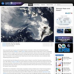
Though seldom so thick or widespread, the haze is common in Hawai'i. It forms when sulfur dioxide from the islands’ volcanoes mixes with oxygen and water in the atmosphere.
Sarychev Peak Eruption, Kuril Islands. A fortuitous orbit of the International Space Station allowed the astronauts this striking view of Sarychev Volcano (Kuril Islands, northeast of Japan) in an early stage of eruption on June 12, 2009.
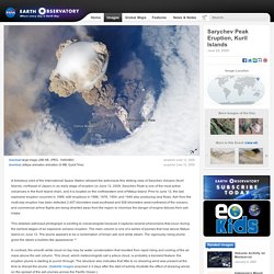
Sarychev Peak is one of the most active volcanoes in the Kuril Island chain, and it is located on the northwestern end of Matua Island. Prior to June 12, the last explosive eruption occurred in 1989, with eruptions in 1986, 1976, 1954, and 1946 also producing lava flows. Ash from the multi-day eruption has been detected 2,407 kilometers east-southeast and 926 kilometers west-northwest of the volcano, and commercial airline flights are being diverted away from the region to minimize the danger of engine failures from ash intake.
This detailed astronaut photograph is exciting to volcanologists because it captures several phenomena that occur during the earliest stages of an explosive volcanic eruption.
NOVA - Official Website. Meet the Volcanoes Posted: January 3, 2013 Narrator:You probably have a pretty good idea what this is.

Hawaiʻi Hot Lava. Scanning Electron Microscope image of volcanic ash. Cascades Volcano Observatory. Researchers use geophysics to locate aquifers at Mount St.
Measuring Lava Flow. Summary Students learn how volume, viscosity and slope are factors that affect the surface area that lava covers. Using clear transparency grids and liquid soap, students conduct experiments, make measurements and collect data. They also brainstorm possible solutions to lava flow problems as if they were geochemical engineers, and come to understand how the properties of lava are applicable to other liquids. Engineering Connection Many types of engineers must understand the properties of liquids, including how they behave differently depending on their volume, viscosity and slope. Educational Standards Each TeachEngineering lesson or activity is correlated to one or more K-12 science, technology, engineering or math (STEM) educational standards.
All 100,000+ K-12 STEM standards covered in TeachEngineering are collected, maintained and packaged by the Achievement Standard Network (ASN), a project of JES & Co.
Fs2014-3119. Volcano Resources. Volcano Resources 11 19 13. Volcano Resources 11 19 13.


