

Sound Waves and Music Review - Answers. Sound and Music Review Navigate to:
Light and Color Review - Answers. Light Waves and Color Review Navigate to: Review Session Home - Topic Listing Light Waves and Color - Home || Printable Version || Questions with Links Answers to Questions: All || #1-#11 || #12-#20 || #21-#28.
Basic Electromagnetism and Electromagnetic Induction Worksheet - Basic Electricity. The coil will tend to compress as current travels through its loops.
Challenge question: what will happen to a wire coil if alternating current is passed through it instead of direct current? Will the coil compress, extend, or do something entirely different? Notes: Open Educational Resources - UEN. Utah's Open Textbook Projects Effective resources are available to provide Utah teachers, students, and parents with materials that support the Utah Core Standards, instruction, and teaching.
These resources are created by groups of content and teaching experts, including university faculty, district and school specialists, teachers, and The Utah State Board of Education staff. Must an object moving at a constant velocity have zero net force? - Updated 2017. Resources for Teachers / Useful Web Links - Department of Earth, Atmospheric, and Planetary Sciences - Purdue University. /* Any CSS placed in this text area will be placed inside of a style tag located in the head section of the page.
. */ Soil and Soil Dynamics. Plant and Soil Sciences eLibrary. Through the interactions of these four soil processes, the soil constituents are reorganized into visibly, chemically, and/or physically distinct layers, referred to as horizons.
There are five soil horizons: O, A, E, B, and C. (R is used to denote bedrock.) There is no set order for these horizons within a soil. Newton's Law Gravity Equations Formulas Calculator - Force Between Objects. How to Read a Topo Map. Map Reading Activity: Topography Printout. Topographic Map Contour Lines - Topographic Map Contour Lines. Contour lines are the greatest distinguishing feature of a topographic map.
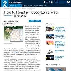
Contour lines are lines drawn on a map connecting points of equal elevation, meaning if you physically followed a contour line, elevation would remain constant. Contour lines show elevation and the shape of the terrain. They're useful because they illustrate the shape of the land surface -- its topography-- on the map. Slope_and_Topographic_Maps. Soil and Water Relationships. Soil moisture limits forage production potential the most in semiarid regions.
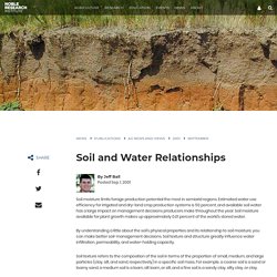
Estimated water use efficiency for irrigated and dry-land crop production systems is 50 percent, and available soil water has a large impact on management decisions producers make throughout the year. Soil moisture available for plant growth makes up approximately 0.01 percent of the world's stored water. Esrt2011 engr. The Statue of Liberty was red before it turned green. New York's iconic, blue-green statue of liberty wasn't always green.
When the statue was gifted to the US from France in 1885, she was actually a shiny copper color. A new video reveals the chemical reactions involving oxygen and even air pollution that led to her color change from copper to liberty green. Pictured is the statue of liberty in 1900 during its color transition to the blue-green color it is today. The statue's color change was as a result of oxidation reactions between copper and the air, a new video has revealed. Fault Lines: Facts About Cracks in the Earth. Faults are fractures in Earth's crust where rocks on either side of the crack have slid past each other.

Sometimes the cracks are tiny, as thin as hair, with barely noticeable movement between the rock layers. But faults can also be hundreds of miles long, such as the San Andreas Fault in California and the Anatolian Fault in Turkey, both of which are visible from space. There are three kinds of faults: strike-slip, normal and thrust (reverse) faults, said Nicholas van der Elst, a seismologist at Columbia University's Lamont-Doherty Earth Observatory in Palisades, New York. Each type is the outcome of different forces pushing or pulling on the crust, causing rocks to slide up, down or past each other. Earth Science Lessons, Printables, & Resources - TeacherVision. HOW A SEISMIC MOVEMENT IS PRODUCED EARTHQUAKE WAVES SEISMOLOGY ANIMATION WELL EXPLAINED. What Is Earthquake.
Types of Faults. Plate Tectonics. Youtube. Earthquakes Living Lab: FAQs about P Waves, S Waves and More - Activity - www.teachengineering.org. Summary Students learn what causes earthquakes, how we measure and locate them, and their effects and consequences. Through the online Earthquakes Living Lab, student pairs explore various types of seismic waves and the differences between shear waves and compressional waves. They conduct research using the portion of the living lab that focuses primarily on the instruments, methods and data used to measure and locate earthquakes. 3-Component Seismogram Records Seismic-wave Motion- Incorporated Research Institutions for Seismology. How do we capture the motion of an earthquake? Modern seismometers include 3 elements to determine the simultaneous movement in 3 directions: up-down, north-south,and east-west.
Each direction of movement gives information about the earthquake. 11d Earthquake Problems Tutorial. Divergent Boundary—Fast Spreading Ridge Educational. Convection currents Planet Earth. Convection Currents - iScience Year 9. Plate Tectonics Basics. List of fault zones - Wikipedia. Beyond San Andreas: 5 Scariest Fault Lines in the U.S. If you saw the Warner Bros. disaster movie, San Andreas, then you know all about the infamous California fault line and its potential for causing chaos. But why does the San Andreas Fault get all the attention in movieland?
Contrary to popular belief, this isn’t the only fault system threatening imminent disaster. America's Risk New Madrid Fault Lines Quake Divide the U.S. May 4-17, 2011. Faults. Geology and Geophysics. Like most stories in geology, this one starts beneath the surface. As you may know, the continents we live on are parts of moving plates.
Most of the action takes place where plates meet. Plates may collide, pull apart, or scrape past each other. All the stress and strain produced by moving plates builds up in the Earth's rocky crust until it simply can't take it any more. Teacher Features California Geological Survey - Teacher Feature-California Has Its Faults. California Has Its Faults From January/February 1992 issue of California Geology magazine. A Model of Three Faults. GEOLOGIC TIME SCALE - Home. Virtual Silurian Reef. Chapter 5 Prehistoric Earth. Chapter 5 focuses on Prehistoric Earth. Resources for Teachers can be found under the Chapter #4 Copymaster. Select from the options on the right to proceed.
Prehistoric means before written history. Synopsis of Modeling Instruction – American Modeling Teachers Association. Human Biology Online Course. Crash Course Big History #3: The Solar System & the Earth. Education. NASA Education Programs and Projects A-Z list of education opportunities that NASA offers throughout the year NASA's Education Calendar The calendar features information about NASA Education opportunities for students and educators. Total Solar Eclipse 2017. Next Generation Science Standards. Biology Textbook - Mr. Miller's Classes. Earth Science Teaching: Lesson Plans, Classroom Activities. BetterLesson. Unit Description The Geology Topics Unit from www.sciencepowerpoint.com on BetterLesson.org A 3700 slide PowerPoint becomes the roadmap for an incredibly interactive and engaging learning experience.
Earth Science Lessons, Printables, & Resources - TeacherVision. Earth Science Lesson Plans. Mr. Gabrielse's Physics Class.