

Holdridge life zones. Holdridge life zone classification scheme.
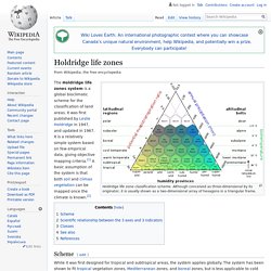
Although conceived as three-dimensional by its originator, it is usually shown as a two-dimensional array of hexagons in a triangular frame. The Holdridge life zones system is a global bioclimatic scheme for the classification of land areas. It was first published by Leslie Holdridge in 1947, and updated in 1967. It is a relatively simple system based on few empirical data, giving objective mapping criteria.[1] A basic assumption of the system is that both soil and climax vegetation can be mapped once the climate is known.[2] Scheme[edit] While it was first designed for tropical and subtropical areas, the system applies globally.
On the Dynamical Causes of Variability in the Rain-Shadow Effect: A Case Study of the Washington Cascades: Journal of Hydrometeorology: Vol 14, No 1. One of the most distinctive features of mountain climates is the “rain-shadow effect”—the sharp decline in precipitation often observed in the lee of mountain ranges.
In the midlatitudes where prevailing winds are westerly, particularly strong rain shadows are associated with mountain ranges oriented north–south, such as the Sierra Nevada, the Cascades, the Southern Alps, and the southern Andes. In the lee of these ranges, annual precipitation is often an order of magnitude lower than at the wettest locations upstream of their crests, leading to significant ecological, hydrological, and economic differences between eastern and western slopes.
The basic physics of the rain-shadow effect is well known (e.g., Smith 1979; Roe 2005). Five factors in climate complexity - The Howler Magazine. Rain shadow. Thermal equator. Sea Surface Temperature Analysis clearly shows highest temperatures (28°C and more) along the 10° North latitude and not along the geographic equator.
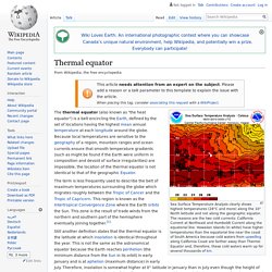
The reasons are the two cold currents: California Current at Northeast and Humboldt Current along the equatorial line. Hawaiian Islands (in white) have higher temperatures than the equatorial line near the coast of South America because cold waters from upwelling along California Coast are farther away than Thermic Equator and, therefore, these cold waters warm up for several thousands of km. The thermal equator (also known as "the heat equator") is a belt encircling the Earth, defined by the set of locations having the highest mean annual temperature at each longitude around the globe. The term is less frequently used to describe the belt of maximum temperatures surrounding the globe which migrates roughly between the Tropic of Cancer and the Tropic of Capricorn.
See also[edit] Solar equator References[edit] Prevailing winds. Winds are part of Earth's atmospheric circulation.
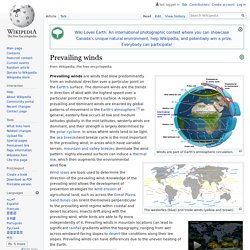
The westerlies (blue) and trade winds (yellow and brown) Global surface wind vector flow lines colored by wind speed from June 1, 2011 to October 31, 2011. Prevailing winds are winds that blow predominantly from an individual direction over a particular point on the Earth's surface. The dominant winds are the trends in direction of wind with the highest speed over a particular point on the Earth's surface. A region's prevailing and dominant winds are enacted by global patterns of movement in the Earth's atmosphere.[1] In general, easterly flow occurs at low and medium latitudes globally. Determination for a location[edit] Trade winds. The westerlies (blue arrows) and trade winds (yellow and brown arrows) The trade winds are the prevailing pattern of surface winds from the east toward the west (easterly) found in the tropics, within the lower portion of the Earth's atmosphere, in the lower part of the troposphere near the Earth's equator.
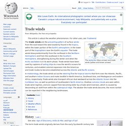
The trade winds blow predominantly from the northeast in the Northern Hemisphere and from the southeast in the Southern Hemisphere, strengthening during the winter and when the Arctic oscillation is in its warm phase. Trade winds have been used by captains of sailing ships to cross the world's oceans for centuries, and enabled colonial expansion into the Americas and trade routes to become established across the Atlantic and Pacific oceans. In meteorology, the trade winds act as the steering flow for tropical storms that form over the Atlantic, Pacific, and southern Indian Oceans and make landfall in North America, Southeast Asia, and Madagascar and eastern Africa, respectively.
(PDF) The Role of the Andes in the Diversification and Biogeography of Neotropical Mammals. Inside Costa Rica MobileNew Species of Mammal Discovered in Andes » Inside Costa Rica. Climate Change and Biodiversity - Thomas E. Lovejoy. Costa Rica Weather Patterns - Pacific & Caribbean Coasts. Costa Rica weather consists of two seasons: dry and rainy.

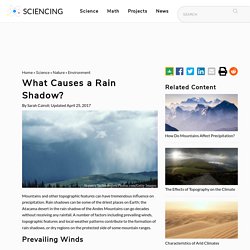
The dry season lasts from December to April, and the rainy season lasts from May to November. Dry season is called verano (“summer”) and rainy season is called invierno (“winter”). This is often confusing to visitors from other countries, where “summer” and “winter” months are reversed. Within Costa Rica, however, there’s significant variation in weather. Along the north Pacific coast — the driest part of Costa Rica — the dry season lasts six months (November to May), and average annual rainfall is 1.7 meters (5.6 feet). Definition of Rain Shadow by Merriam-Webster. What Causes a Rain Shadow? Hemera Technologies/Photos.com/Getty Images Mountains and other topographic features can have tremendous influence on precipitation.
What Is The Rain Shadow Effect? Description Often times, mountains stand as barriers to clouds so as to prevent precipitation from falling on certain sides of them.
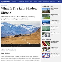
This phenomenon is the result of the warm moist air that rises accompanied by prevailing winds at the tops of mountains. The warm air mass is pushed upwards to higher altitudes to produce rain or showers, and when it passes over a mountain it cools down. As it hurdles the top of a mountain, it quickly dries up and goes down the other side of a mountain, gaining back its warm mass which sucks up moisture as it travels downwards.
What is a Rain Shadow? - Higgins Storm Chasing. Rain shadows are related to and caused by orographic lifting.
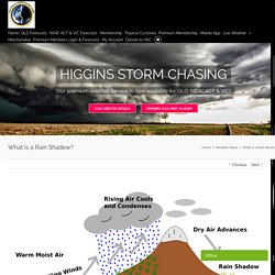
The process causes the opposite effects of rainfall by orographic lifting, on the opposite side of the mountain rain and as a result, rain shadows are renowned for producing some of the driest climates on planet Earth. Luckily, Australia doesn’t experience harsh rain shadow and this is largely due to the way our Country is shaped, however we do still experience them and in more ways than one. So what are rain shadows, how do they occur and how do they impact Australia? The Rain Shadow Effect: Definition & Explanation - Video & Lesson Transcript. Rain Shadow. This illustration shows how a rain shadow forms on the wind-protected side of a mountain.

Click on image for full size Image part of the public domain. Nationalgeographic. Rain shadow. Picture that has wind blowing up a mountain. The water falls out and dries the air. When the air goes down the other side, it gets warmer, holds water and does not rain A rain shadow is an area of land that lies behind a mountain which gets almost no rainfall. Rain shadow. Wind shear. Cirrus uncinus ice crystal plumes showing high level wind shear, with changes in wind speed and direction. Wind shear (or windshear), sometimes referred to as wind gradient, is a difference in wind speed or direction over a relatively short distance in the atmosphere. Atmospheric wind shear is normally described as either vertical or horizontal wind shear.
Vertical wind shear is a change in wind speed or direction with change in altitude. Horizontal wind shear is a change in wind speed with change in lateral position for a given altitude.[1] Wind shear is a microscale meteorological phenomenon occurring over a very small distance, but it can be associated with mesoscale or synoptic scale weather features such as squall lines and cold fronts.
Outflow boundary. Outflow boundary on radar with radial velocity and frontal boundary drawn in. Outflow boundaries create low-level wind shear which can be hazardous during aircraft takeoffs and landings. If a thunderstorm runs into an outflow boundary, the low-level wind shear from the boundary can cause thunderstorms to exhibit rotation at the base of the storm, at times causing tornadic activity.
Strong versions of these features known as downbursts can be generated in environments of vertical wind shear and mid-level dry air. Microbursts have a diameter of influence less than 4 kilometres (2.5 mi), while macrobursts occur over a diameter greater than 4 kilometres (2.5 mi). Wet microbursts occur in atmospheres where the low levels are saturated, while dry microbursts occur in drier atmospheres from high-based thunderstorms.
Tropical cyclone. Rotating storm system with a closed, low-level circulation A tropical cyclone is a rapidly rotating storm system characterized by a low-pressure center, a closed low-level atmospheric circulation, strong winds, and a spiral arrangement of thunderstorms that produce heavy rain. Depending on its location and strength, a tropical cyclone is referred to by different names, including hurricane (/ˈhʌrɪkən, -keɪn/),[1][2][3] typhoon (/taɪˈfuːn/), tropical storm, cyclonic storm, tropical depression, and simply cyclone.[4] A hurricane is a tropical cyclone that occurs in the Atlantic Ocean and northeastern Pacific Ocean, and a typhoon occurs in the northwestern Pacific Ocean; in the south Pacific or Indian Ocean, comparable storms are referred to simply as "tropical cyclones" or "severe cyclonic storms".[4] The strong rotating winds of a tropical cyclone are a result of the conservation of angular momentum imparted by the Earth's rotation as air flows inwards toward the axis of rotation.
Size. Tropical cyclogenesis. Global tropical cyclone tracks between 1985 and 2005, indicating the areas where tropical cyclones usually develop. Outgoing longwave radiation. 2003-2010 Annual mean OLR Outgoing Long-wave Radiation (OLR) is electromagnetic radiation of wavelengths between 3.0 and 100 µm emitted from Earth and its atmosphere out to space in the form of thermal radiation. it is also referred to as up-welling long-wave radiation and terrestrial long-wave flux, among others.
El Niño–Southern Oscillation. Irregularly periodic variation in winds and sea surface temperatures over the tropical eastern Pacific Ocean Southern Oscillation Index timeseries 1876–2017. Convergence zone. Intertropical Convergence Zone. Upwelling. Oceanic basin. Large geologic basins that are below sea level Diagrammatic cross-section of an ocean basin, showing the various geographic features In hydrology, an oceanic basin may be anywhere on Earth that is covered by seawater but geologically ocean basins are large geologic basins that are below sea level.
Thermohaline circulation. Southern Hemisphere. The Southern Hemisphere highlighted in yellow. The hemispheres appear to be unequal in this image due to Antarctica not being shown, but in reality are the same size. Franz Josef Land. Hjalmar Johansen. Fredrik Hjalmar Johansen (15 May 1867 – 3 January 1913) was a Norwegian polar explorer. He participated on the first and third Fram expeditions. He shipped out with the Fridtjof Nansen expedition in 1893–1896, and accompanied Nansen to notch a new Farthest North record near the North Pole. Nansen's Fram expedition. Fridtjof Nansen. Oceanography. Vagn Walfrid Ekman. Ekman spiral. Ocean current. Atmospheric circulation. Coriolis force. NOAA SciJinks – All About Weather. Centrifugal force. Inertial frame of reference. Newton's laws of motion. Meteorology. Water wheel. Gaspard-Gustave de Coriolis.
Coriolis force.