
Orlando, FL Weather Forecast. Maps - MSN Weather. Hurricane Irma Tracker. ( cyclocane is a CYCLOne and hurriCANE tracker by hayley ) English Español Deutsch Français Irma Current Status Current Wind Speed 115 knots / 130 MPH Max Predicted Wind Speed 130 knots / 150 MPH at Current Watches/Warnings / Radar / Satellite (above image is example - see my future radar site for latest) If a tropical storm or hurricane is threatening land, you can check my future radar for an idea of what radar might look like as the storm approaches.
Irma Land Hazards NWS Local Hurricane Statements San Juan PR AL112017 **IRMA STRENGTHENS AS IT HEADS TOWARD THE LEEWARD ISLANDS** SAN JUAN PR **IRMA SE FORTALECE A MEDIDA QUE SE APROXIMA A LAS ISLAS DE SOTAVENTO** STORM SURGE - The combination of a dangerous storm surge and large breaking waves will raise water levels by as much as 6 to 9 feet above normal tide levels along the coasts of the extreme northern Leeward Islands within the hurricane warning area near and to the north of the center of Irma. Irma Tracker Irma Satellite Loop. Atlantic Temps. Hurricane Irma Tracker and Storm Safety Tips - weather.com. Watches and Warnings A watch means hurricane or tropical storm conditions are possible within 48 hours.
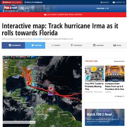
A warning means those conditions are expected within 36 hours. now viewing Tropical-Storm-Force Wind Probabilities. Interactive map: Track hurricane Irma as it rolls towards Florida. As Floridians cleared supermarkets of bottled water and emptied gas pumps, people in the northeastern Caribbean were making last minute-preparations before powerful Hurricane Irma hit their islands.

Late Tuesday, the massive Category 5 storm was almost upon islands like Antigua and Barbuda with near-record 185 mph sustained winds. In its 11 p.m. ET advisory, the US National Hurricane Center said the eye of the hurricane was 50 miles from the two islands. The center of the storm was moving to the west-northwest at 15 mph. The hurricane center said the extremely dangerous core of Irma would hit the northern Leeward Islands — which include Antigua and Barbuda, St.
It’s too early to tell whether the storm will make landfall on the US mainland, but forecasts show it could turn toward Florida over the weekend. Forecasters’ most immediate concerns are for the people of the northeastern Caribbean, the hurricane center’s Michael Brennan said. One Twitter user in St. Fishermen get boats out of water. Interactive map: Track hurricane Irma as it rolls towards Florida. Interactive Weather Map and Radar. Exact eiendomsmeglere - Ensjø Tips en venn om denne annonsen Brinken 11, 0654 Oslo Prisantydning Verditakst Fellesgjeld Totalpris Lånetakst Fellesformue Felleskost/mnd.

Primærrom 46 m² Bruksareal 48 m² Soverom Rom Etasje Boligtype Leilighet Eieform Eier (Selveier) Tomteareal 2 876 m² eiet. Interactive Radar. 14 day weather outlook of Oslo. Orlando weather forecast. Værradar for Sør-Norge. Weather radar for South Norway The map shows where precipitation (rain, sleet, snow etc) falls, the colour giving an indication of the amount.

By emitting radar waves the radar registers how precipitation moves . It will then receive echoes if the waves hit precipitation particles. The animation shows precipitation during the last hours, the last picture in the sequence being the most recent. The time at which it was taken is given (in local time) in the upper right corner. Under certain conditions the radar waves are deflected and hit the ground instead, giving false echoes. South Norway Southeast Norway Southwest Norway Western Norway Central Norway Nordland and Troms Troms and Finnmark Finnmark. TDOT Smartmap. Orlando Weather: Local Orlando weather forecast and news. Radar - JustWeather.com - Orlando Local Weather, Forecast, Severe Alerts. Yr.no – Været for Norge og verden fra Meteorologisk institutt og NRK. Track Hurricane Danielle, Track Tropical Storm Earl.
National Hurricane Center. Været for Sørenga, Oslo, Oslo -Dagbladet.no.