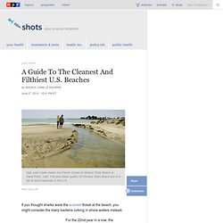

Day and Night in New York City Captured in Single Images [8 Pictures] A Guide To The Cleanest And Filthiest U.S. Beaches : Shots - Health Blog. Hide captionSan Juan Creek meets the Pacific Ocean at Doheny State Beach in Dana Point, Calif.

The poor water quality off Doheny State Beach put in a list of worst beaches in the U.S. Reed Saxon/AP San Juan Creek meets the Pacific Ocean at Doheny State Beach in Dana Point, Calif. The poor water quality off Doheny State Beach put in a list of worst beaches in the U.S. If you thought sharks were the scariest threat at the beach, you might consider the lowly bacteria lurking in shore waters instead. For the 22nd year in a row, the Natural Resources Defense Council has issued a report on the nation's filthiest and cleanest beaches. Bacteria in the water are the main safety issue. In findings that echo rankings released in the last few years, Avalon and Doheny beaches in California and several beaches in Louisiana were among the worst — again.
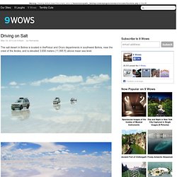
Despite the group's reports, there's been little improvement in water quality. Harmful water bacteria often come from animal or human waste. Morning Glory Rainbow Pool. Salt Flat Mirror. Driving on Salt. May 18, 2012 at 4:00pm | by Hernando The salt desert in Bolivia is located in thePotosí and Oruro departments in southwest Bolivia, near the crest of the Andes, and is elevated 3,656 meters (11,995 ft) above mean sea level.

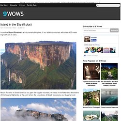
Via: onebigphoto.com Like 9 Wows for daily content like this! Island in the Sky (8 pics) April 29, 2012 at 2:00pm | by Steven Incredible Mount Roraima is a truly remarkable place.

It is a tabletop mountain with sheer 400-meter high cliffs on all sides. Mount Roraima in South America, is a giant flat-topped mountain, or mesa, in the Pakaraima Mountains of the Guiana Highlands, at the point where the boundaries of Brazil, Venezuela, and Guyana meet. There is only one ‘easy’ way up, on a natural staircase-like ramp on the Venezuelan side – to get up any other way takes and experienced rock climber. On the top of the mountain it rains almost every day, washing away most of the nutrients for plants to grow and creating a unique landscape on the bare sandstone surface. About 9 miles (14 km) long and 9,094 feet (2,772 metres) high, it is the source of many rivers of Guyana, and of the Amazon and Orinoco. Via: all-that-is-interesting Like 9 Wows for daily content like this! Fortbragg.com. Tents - Camping & Hiking. M13's Two Wheeled Adventure Tour.
Tour Taiwan on motorcycles and scooters with me, M13.

I have over 15 years of motorcycle riding experience and over 10 years experience of touring Taiwan. I’ve partnered up with Taiwan’s most experienced locals to plan the perfect Asian experience. I will take you to places of pure beauty. Ride on roads that can’t be experienced through photos or videos. And experience sights, smells and tastes only a select number of people in the world have ever experienced before. A tour with us will be truly an exciting, refreshing, memorable trip of a lifetime. Take security in the fact that I will be leading the way and acting as a blocker for traffic. Continue to the Tours Booking page for available tours, tour information, pricing and tour registration. Tour Description Video: