
Euroopan valtiot ja niiden pääkaupungit Flashcards. Eurooppa: Pääkaupungit - Karttavisapelit. EURO RUN -PELI - Euro - Yhteinen rahamme. We wish to use the electronic media and/or print media produced by the European Central Bank (ECB) to inform others.
We declare that: 1. Any information or materials received from the ECB will be used for information purposes only. 2. We will not use the “€ OUR MONEY” logo for purposes that could be detrimental to the euro, or for commercial or advertising purposes, and we will adhere to the style guidelines provided in the Partnership Programme. 3. Any electronic materials, pictures, files or documents provided by the ECB will remain its sole property. The ECB will reserve its or third-party copyrights.
This privacy notice is made on behalf of the European Central Bank (ECB) and applies to Havas 360, its sub-contractors and all central banks referred to as data processors below. A. 1) You have the right to see the information that we have about you and to get mistakes corrected by contacting Havas 360; 2) You have the right to delete your account with Havas 360. B. C. Tutkimusretkellä Euroopassa! Europa - Tietoa Euroopan unionista. Toporopa-oppimispelit: Euroopan maantiede.
2nd Largest Nationality Living In Each European Country. Map by reddit user JimWillFixIt69 The map above shows the flag of the 2nd largest nationality, by country of birth, living in each European country.
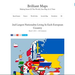
Thus, it may include citizens and those who have moved temporarily for work. Nevertheless, there are many surprises, such as: Ireland is no longer the largest source of foreign born residents to the UK. Since 2011, they’ve dropped to 4th, behind India, Poland and Pakistan. Controversially, the map author decided to include Kurdistan as a separate nation. Finally, because I know somebody is going to mention it, the United kingdom is treated as single country in the map above in keeping with the Countries in the International Organization for Standardization.
For more you should also have a look at the Most Popular Migrant Destinations By Country map. Notice any other interesting, surprising or mistaken things in the map above? European Country Quiz. NA0114598FIC 002. NA0114598FIC_002.pdf;pgid=GSPefJMEtXBSR0dT6jbGakZD0000VdCbdnCZ;sid=YdTpkoiKObXp-NCM9mZ3NeqvZgfvQSpJHYQ=?FileName=NA0114598FIC_002.
Montessorimaterial - Europe Weather. Select interests to add to your dock Health Cold & FluAllergiesRespiratoryArthritisMigraineSinus TravelAstronomyEvents A.M.
Planner DrivingSchool DayHair DaySnow Days Home & Garden D.I.Y.Lawn & GardenHome EnergyEntertaining. Kiitos tilauksestanne! Incredibly Detailed Map Of The World's Religions. Map created by reddit user scolbert08 The incredibly detailed map of the world’s religions above, was created by reddit user scolbert08.
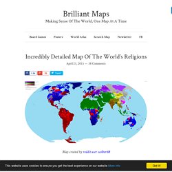
To see the full resolution version just click on it. It shows what the biggest religion is by census area in each country, along with its level of support. For example, in large parts of British Columbia the most common answer on the census is no religion, but the intensity of that feeling varies widely.
Another important thing to note is that while Christianity is divided between Catholicism, Protestantism and Orthodox denominations, Islam is not similarly divided between Sunnis and Shias. Also, the map likely wildly overstates the religiosity of Scandinavians, since the data is based on state Church records and everyone is assigned to a church at birth. Untitled.
Eurooppa kartalla. Karttapelejä Euroopasta. European Countries Flags & Capitals Archives - KidsPressMagazine.com. The World's Largest Poster and Print Store! Euratlas Europe Photos. 2nd Largest Nationality Living In Each European Country. TAVOITTEET OPS 2016. TAVOITTEET. TAVOITTEET. TAVOITTEET. TAVOITTEET. Euroopan maantiedon opetuksen jäsentelymahdollisuuksia ( vanha ops)
UM%20sein%C3%A4kalenteri%202016. TODELLINEN KOKO? Ohjeet. Kuinka suuri Suomi on ja muita karttojen kummallisuuksia. Eräs mielikuvakarttojen automaattinen vääristäjä on perinteinen maailmankartta.
Kun pallomainen planeetta piirretään millaiseksi kaksiulotteiseksi kuvaksi tahansa, jotain vääristyy aina. Useimmiten uhrina ovat napojen lähellä sijaitsevat kohteet, jotka venyvät suhteessa suuremmiksi kuin päiväntasaajan tienoilla olevat paikat. Tämän huomaa vaikkapa TheTrueSizessa hiissaamalla Suomea pohjoisesta etelään, tai pyöräyttämällä kalvoa hieman kenolleen alalaidan kompassista. Pelkästään kääntämällä Suomi paikallaan ylösalaisin on jo ihan opettavaista. ScribbleMapsin tai FreeMapToolsin etäisyyslaskimilla huomaa, kuinka myös etäisyydet ja suunnat vääristyvät karttaprojektioissa. Tietokonepelit havainnollistavat projektioiden vääristysefektejä interaktiivisesti.
Sivuhuomautus: Jos lähdit lukemaan juttua otsikon pohjalta, tietääksesi Suomen pinta-alan tarkan suuruuden, niin on pakko tuottaa pettymys: Sitä ei nimittäin tiedetä tarkkaan, ainoastaan minimi- ja maksimiarviot tiedetään. SUNNITTELE MATKA. Euroopan valtiot. Maailman ihmisluku 2015 kartogrammina. Yksi ruutu = 500 000 ihmistä. Untitled. Agenda2030.