
Fairhope+Gullies+(Final) Fairhope Public Library : Item Viewer. Fairhope Public Library : Item Viewer. Fairhope - Mobile Bay National Estuary Program. Fairhope Volanta Watershed Planning and Stormwater Improvements The purpose of this project is to study the Volanta Gulley Watershed in the City of Fairhope and develop and implement low impact stormwater management projects and practices throughout.
Fairhope's increase in population over the past decade, combined with an average rainfall of over sixty-five inches per year, results inincreased nonpoint source pollution in the nearby creeks and streams which empty into Mobile Bay and the Gulf of Mexico. The solution is to create stormwater management projects and practices that allieviate this problem. Volanta Gully Watershed Management Plan Volanta Gully Watershed Phase I Drainage Restoration Projects Fairhope Gullies Article Fairhope’s Gullies are natural resources of historical and biological significance to the community.
They suffer from exotic invasive plants, increased storm water flow, and erosion. Stacks, Big Head, and Bayou Carbon gully land donation. Gulf of Mexico. The Gulf of Mexico (Spanish: Golfo de México) is an ocean basin largely surrounded by the North American continent and the island of Cuba.[1] It is bounded on the northeast, north and northwest by the Gulf Coast of the United States, on the southwest and south by Mexico, and on the southeast by Cuba.
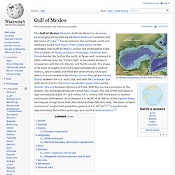
The US states of Texas, Louisiana, Mississippi, Alabama, and Florida border the Gulf on the north. In Texas and Louisiana it is often referred to as the "Third Coast" in the United States, in comparison with the U.S. Atlantic and Pacific coasts. The Unusual Case of the Mexican Subduction Zone. Mexico is located on one of Earth's subduction zones, where the ocean floor of the Cocos tectonic plate is forcing its way down ("subducting") beneath the continental edge of the North American plate.
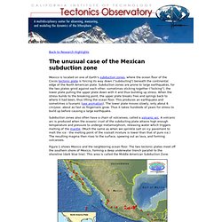
Subduction zones are prone to large earthquakes, for the two plates grind against each other, sometimes sticking together ("locking"), the lower plate pulling the upper plate down with it and thus building up stress. When the stress builds to the breaking point, the upper plate breaks free and springs back to where it had been, thus lifting the ocean floor. This produces an earthquake and sometimes a tsunami (see animation). The lower plate moves slowly, only about 6 cm/year, about as fast as fingernails grow. Thus it takes hundreds of years for stress to build up before causing a large earthquake.
Subduction zones also often have a chain of volcanoes, called a volcanic arc. Figure 1 shows Mexico and the neighboring ocean floor. Figure 1. Category:Geotourism. Geotourism (from “geographical character”): is defined as tourism that sustains or enhances the geographical character of a place—its environment, culture, aesthetics, heritage, and the well-being of its residents.
The concept was introduced publicly in a 2002 report by the Travel Industry Association of America and National Geographic Traveler magazine. National Geographic senior editor Jonathan B. Tourtellot and his wife, Sally Bensusen, coined the term in 1997 in response to requests for a term and concept more encompassing than “ecotourism” and “sustainable tourism.” Like true ecotourism, geotourism promotes a virtuous circle whereby tourism revenues provide a local incentive to protect what tourists are coming to see, but extends the principle beyond nature and ecology to incorporate all characteristics that contribute to “sense of place”—historic structures, living and traditional culture, landscapes, cuisine, arts and artisanry, as well as local flora and fauna.
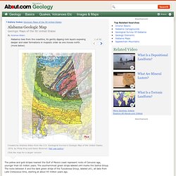
Alabama to be part of National Geographic geotourism project. Alabama Geologic Map. Alabama rises from the coastline, its gently dipping rock layers exposing deeper and older formations in majestic order as one moves north.
(more below) Created by Andrew Alden from the U.S. Encyclopedia of Alabama: Alabama's Coastline. Orange BeachAlabama's coastline, home to the beaches of the Gulf of Mexico, is an important part of the quality of life for many of the state's citizens and one of the state's greatest economic and environmental assets.
The white, sandy beaches of the coastal towns of Orange Beach and Gulf Shores and Dauphin Island are beloved and popular vacation destinations for Alabamians and out-of-state tourists. The fine quality of the sand and gentleness of the surf make for some of the prettiest beaches in the world and are the top tourist destination in the state. The tourism industry in south Baldwin County provides more than 50,000 jobs and generates more than $2 billion in revenue annually, and beaches are the linchpin of that industry. Alabama's shoreline along the Gulf of Mexico stretches for 60 miles. Coastal Geology. Geology of Alabama. The geology of Alabama is marked by abundant geologic resources and a variety of geologic structures from folded mountains in the north to sandy beaches along the Gulf of Mexico coast.
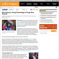
Alabama spans three continental geologic provinces as defined by the United States Geological Survey, the Atlantic Plain, Appalachian Highlands, and Interior Plains.[1][2] The Geological Survey of Alabama breaks these provinces down into more specific physiographic provinces.[3] Provinces[edit] East Gulf Coastal Plain [4][edit] Geo-Literacy: Using Technology to Forge New Ground. Students use visual learning and communication tools to build an in-depth understanding of geography, geology, and local history.
VIDEO: The Geo-Literacy Project: Students Use Technology to Explore Their World Running Time: 5 min. Editor's Note: Since this article was written in 2003, teacher Eva La Mar has moved on from Tolenas Elementary School to teach third grade in Oregon. Geology Projects - Lessons ideas from Pattie Elementary School Teachers. Fth Grade Geology Project Assignments. S Study of Hydraulic Fracturing and Its Potential Impact on Drinking Water Resources. At the request of Congress, EPA is conducting a study to better understand any potential impacts of hydraulic fracturing on drinking water resources.
Fracking still a possibility in Talladega National Forest. MONTGOMERY, Ala.
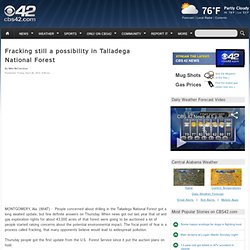
(WIAT) - People concerned about drilling in the Talladega National Forest got a long awaited update, but few definite answers on Thursday. When news got out last year that oil and gas exploration rights for about 43,000 acres of that forest were going to be auctioned a lot of people started raising concerns about the potential environmental impact. The focal point of fear is a process called fracking, that many opponents believe would lead to widespread pollution. Thursday people got the first update from the U.S. Forest Service since it put the auction plans on hold. Can Animals Sense Earthquakes? “Highly unlikely, but not outside the realm of extreme possibilities.”Mulder, F.W. in the “The Jersey Devil” (1993) The earliest documented case of unusual animal behaviour prior to an earthquake is recorded by the Roman historian Aelian in 373 B.C.; five days before an earthquake destroyed the city of Helike (once located at the coast of the Corinthian Gulf) various animals, like rats, weasels, snakes, centipedes and bugs supposedly emerged from the underground and fled from the city.
In the following centuries many other cultures associated earthquakes with animals. According to Japanese myth the cause of earthquakes is the giant catfish Namazu who lives buried in the underground. By moving his tail he can shake the entire earth and unfortunately he loves to cause trouble and havoc. However in early traditions the catfish also acts as premonition of danger, warning people from an imminent catastrophe or by swallowing dangerous water-dragons prevents further catastrophes. Fig.1. & 2. The Earth Has a Future. The Earth Has a History is a video produced by The Geological Society of America (Palmer, 1991) to acquaint nongeologists with the concepts of geologic or “deep” time. A less conventional way to visualize geologic time is to peer into the future. Even short geologic time scales outrun our ability to project human history, whereas many geologic processes will have barely begun to produce visible changes.
Events that are rare or unknown in recorded history become almost inevitable, even frequent, in the near geologic future. This paper will explore the likely future of Earth on geologically short time scales ranging from 1000 yr to 1 m.y. The intent of this paper is to illustrate geologic time by peering into the future, not to make rigorous predictions or speculate about human history. A futurist approach can serve to correct some common misconceptions. There are practical applications for long-term geological prediction. A million years is relatively short in geologic terms.
Low impact. What are Geological Processes? (with pictures) The term "geological processes" describes the natural forces that shape the physical makeup of a planet. Plate tectonics, erosion, chemical weathering and sedimentation are all examples of forces that significantly affect the Earth’s surface and account for its major features. These processes are closely studied by geologists and earth scientists to improve their understanding of the planet’s history; to help locate useful resources, such as metal ores; and to aid the prediction of potentially disastrous events, such as earthquakes, tsunamis and volcanic eruptions.
Plate Tectonics. Alabama. Plate tectonics in alabama - free eBooks download. Sinkholes Not Likely in South Alabama. MOBILE, Ala. (WPMI) A University of South Alabama Geology Professor said though catastrophic sinkholes like those found in Florida recently are not likely in South Alabama, he said other types of sink holes can occur. For the third time in a week, a sinkhole was discovered in West-Central Florida. The most recent one was found Tuesday morning at a home in Pinellas county, Florida. A woman inside the home called 9-1-1 after hearing a cracking noise. Firefighters found extensive cracks inside and outside the home. Several nearby homes were evacuated as a precaution, but nobody was hurt. Monday a sinkhole was discovered in neighboring Hillsborough County, which followed a deadly sinkhole that opened up last Thursday in the same area of Hillsborough County.
Dr. Haywick said limestone is found in most parts of Florida, Louisiana and Northern Alabama, which are prone to what he calls "classic sinkholes". Report on the geology of the coastal plain of Alabama - Geological Survey of Alabama, Eugene Allen Smith, Lawrence Clement Johnson, Daniel W. Langdon (jr), Truman Heminway Aldrich, K. M. Cunningham. Battle of the Beach Sands. Sand is something I ordinarily try not to get on my feet, but the best way to walk on the beach is barefoot.
The soft sand feels great, and there's nothing like kicking off my shoes to sink my toes into powdery-white, squeaky-clean beach sand. It's rejuvenating. Geological Society of America - Educator Resources.