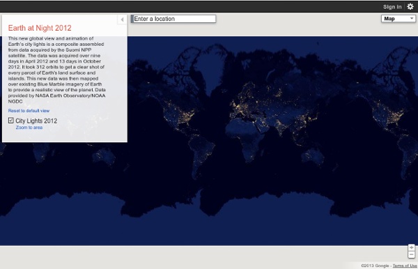


The Nighttime Earth SAN FRANCISCO — The Earth at night looks more beautiful than it ever has before in these incredible new images from NASA's Suomi NPP satellite. These super-high-resolution images, made possible by a new type of infrared sensor on the satellite, were revealed here at the American Geophysical Union conference Dec. 5.The Visible Infrared Imaging Radiometer Suite has a "day-night band" that can detect natural and man-made light with unprecedented resolution and clarity. It can resolve everything from the nocturnal glow of the atmosphere to the light of a single boat at sea. It can detect auroras, wildfires, the reflection of moon and star light off clouds and ice and the lights alongside highways. The sensor has six times better spatial resolution and 250 times better resolution of lighting levels than anything that came before it.The VIIRS instrument works by scanning in 22 different wavelength bands.
Bibliothèque numérique mondiale Description Cette impression photochrome du Champs de Mars à Paris fait partie des "Vues de l'architecture, de monuments et d'autres sites en France" du catalogue de la Detroit Publishing Company (1905). Le Champs de Mars s'étend entre la Tour Eiffel et l'imposante École Militaire dans le septième arrondissement Paris. L'édition 1900 de l'ouvrage de Baedeker Paris et ses environs, avec des itinéraires de Londres à Paris : Manuel du voyageur décrit le parc comme "un grand espace de sable, d'une longueur d'1 km et de 500 mètres de large" qui jusqu'en 1889 avait été utilisé pour des manœuvres militaires. Informations d'édition Detroit Publishing Company, Détroit (Michigan) Langue Français Titre dans la langue d'origine Champs de Mars, Exposition Universal, 1900, Paris, France Lieu Europe > France > Paris Période Thème Mots-clés supplémentaires Type d'élément Images, photographies Description matérielle 1 impression photomécanique : photochromatique, couleur Notes Collection Institution
Global Views on Morality Do you personally believe that married people having an affair is morally acceptable, morally unacceptable, or is it not a moral issue? Do you personally believe that gambling is morally acceptable, morally unacceptable, or is it not a moral issue? Do you personally believe that homosexuality is morally acceptable, morally unacceptable, or is it not a moral issue? Do you personally believe that having an abortion is morally acceptable, morally unacceptable, or is it not a moral issue? Do you personally believe that sex between unmarried adults is morally acceptable, morally unacceptable, or is it not a moral issue? Do you personally believe that drinking alcohol is morally acceptable, morally unacceptable, or is it not a moral issue? Do you personally believe that getting a divorce is morally acceptable, morally unacceptable, or is it not a moral issue? Do you personally believe that using contraceptives is morally acceptable, morally unacceptable, or is it not a moral issue?
Toile Libre | Hébergement d'images Top 60 Chinese Cities Cities are one of the many phenomena that follow a long-tailed distribution. In simple terms there are a few big cities and lots of small ones. The classic way of showing a long tailed distribution (and the method from which the name is taken) is to produce as plot such as that below: The infographic at the top of the post by chinfographics.com demonstrates the distribution in a more engaging and constructive way. One method I have used in the past to demonstrate data with a long tailed distribution is the excellent Wordle tool. Le Labyrinthe du silence un film de Giulio Ricciarelli Guillaume Mouralis est chargé de recherche au CNRS, membre de l'Institut des Sciences sociales du Politique (CNRS / Université Paris Ouest Nanterre). Ses recherches en histoire et sociologie politique portent notamment sur les sorties de guerres, épurations et procès pour crimes de masse. Il travaille actuellement à une histoire sociale du procès de Nuremberg (1945-1946). Parmi ses publications : Une épuration allemande. La RDA en procès 1949-2004, Paris, Fayard, 2008. Giulio Ricciarelli, le réalisateur du Labyrinthe du silence, avoue sa stupéfaction quand il apprit l’histoire du procès de Francfort. LUMIÈRES SUR – Comment résumer l’importance du procès de Francfort en 1963, dont la préparation est relatée par le film Le Labyrinthe du silence ? GUILLAUME MOURALIS – Ce procès est le plus important des trois procès impliquant des employés du camp d’Auschwitz qui se sont déroulés à Francfort dans les années 60. LS – Dans quel contexte s’inscrit-il ? Propos recueillis par Magali Bourrel