
Médiation scientifique et culturelle Quel que soit son établissement de rattachement et le domaine dans lequel s'exerce sa mission, le médiateur vise à établir la relation entre l'individu, l'institution et l'objet. La médiation jouit d'une énorme popularité. Tous les établissements patrimoniaux recevant du public disposent désormais de leurs médiateurs ou animateurs. Les établissements scientifiques se lancent dans de vastes entreprises de ce que l'on appelait autrefois "vulgarisation". A côté des établissements spécialisés dans le domaine (centres culturels, centres d'interprétation) les écoles, les médias, les bibliothèques... sont également investis d'une mission de médiation. Les outils de médiation se sont largement diversifiés au fil du temps. On notera pourtant que la médiation s'exerce toujours dans le même sens : des tenants de la culture savante vers les représentants de la culture populaire. Comment imaginer une véritable culture commune sans cette pollinisation croisée ? photo : the_exploratorium via photopin cc
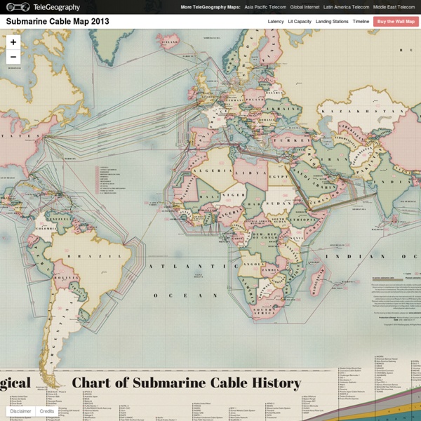
Quinientas cincuenta mil leguas de cable submarino La información querrá ser libre pero su grado de autonomía es muy limitado. El complejo entramado de telecomunicaciones que llamamos Internet depende de antenas, grandes centros de procesamiento de datos y, sobre todo, dos millones y medio de kilómetros de fibra óptica cuya fragilidad se pudo apreciar en toda su extensión cuando la guardia costera egipcia descubrió a tres buceadores cortando cables cerca de la costa de Alejandría el pasado mes de marzo. La red de autopistas submarinas que conecta artificialmente lo que ha separado el mar tiene 200 cables que tienden a uno y otro lado de los continentes, concentrándose en puntos estratégicos. Egipto es uno de esos puntos y la línea atacada (SEA-ME-WE 4), es uno de los cuatro cables que conecta Europa, Oriente Medio y el continente asiático. Lo cierto es que los cables submarinos llevan una existencia llena de callados peligros en la oscuridad del suelo oceánico. Colgar de un hilo La Gran Red Victoriana