background preloader

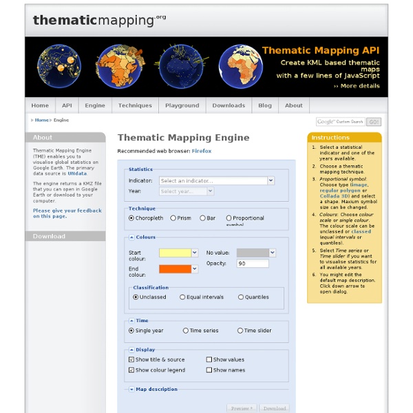
Thematic Mapping Engine - thematicmapping.org

Thematic Mapping Engine - thematicmapping.org

KML Reference - KML - Google Code This section contains an alphabetical reference for all KML elements defined in KML Version 2.2, as well as elements in the Google extension namespace. The class tree for KML elements is shown below. In this diagram, elements to the right on a particular branch in the tree are extensions of the elements to their left. For example, Placemark is a special kind of Feature. It contains all of the elements that belong to Feature, and it adds some elements that are specific to the Placemark element. KML is an open standard officially named the OpenGIS® KML Encoding Standard (OGC KML). The complete XML schema for KML is located at Note: Click an element name in this diagram to jump to its entry in the reference section. Note that abstract elements (shown in boxes in the diagram) are not actually used in KML files. All elements derived from Object can have an id assigned to them. Tip: Viewing KML for Google Earth Features Compatibility About this reference KML fields

Sortez des sentiers battus ! | UrbanDive Mappy Le blog pour tout connaitre de Mappy Sortez des sentiers battus ! Publié le 5 décembre 2011 par Mappy / Catégories : Actualités Désormais, des vues piétonnes de Paris sont visibles sur UrbanDive. Voici un petit florilège de parcs et rues piétonnes où vous balader : Parc Montsouris Passerelle Simone de Beauvoir Quai de la Gare Parc de Bercy Quai de l’Arsenal Parvis de Notre Dame Quai de la Tournelle Beaubourg Saint-Eustache Carrousel du Louvre Fontaine Stravinsky Tour Eiffel La Défense Parc Monceau Et vous, quel est votre lieu préféré ? Suivez nous sur Twitter @UrbanDive pour connaitre toutes les nouveautés du site Articles similaires Laisser un commentaire Votre adresse de messagerie ne sera pas publiée. Vous pouvez utiliser ces balises et attributs HTML : <a href="" title=""><abbr title=""><acronym title=""><b><blockquote cite=""><cite><code><del datetime=""><em><i><q cite=""><strike><strong> Notifiez-moi des commentaires à venir via email. www.mappy.com

Teaching with Google Earth- Awesome Tips and Tutorials Google Earth is a geobrowser that represents the earth as 3 dimensional globe using satellite and aerial imagery, ocean bathymetry and other geographic data over the internet. Google refers to this service as " geographic browser or geobrowser" and provides it to its users in two versions: One is free and the other is pro. Of course the paid version has more advanced features and functionalities, however, the free basic version is generous enough for us in education. Google Earth provides search capabilities and the ability to pan, zoom, rotate, and tilt the view of the Earth. It also offers tools for creating new data and a growing set of layers of data, such as volcanoes and terrain, that reside on Google's servers, and can be displayed in the view. In this resource section, I am going to share with you some important tips and tutorials to help you better use this service in education. Google Earth Video Tutorials Google Earth Drawing and Measuring Google Earth Tours and Placemarks

Gapminder: Unveiling the beauty of statistics for a fact based world view. The Best Tools for Visualization Visualization is a technique to graphically represent sets of data. When data is large or abstract, visualization can help make the data easier to read or understand. There are visualization tools for search, music, networks, online communities, and almost anything else you can think of. Whether you want a desktop application or a web-based tool, there are many specific tools are available on the web that let you visualize all kinds of data. Visualize Social Networks Last.Forward: Thanks to Last.fm's new widget gallery, you can now explore a wide selection of extras to extend your Last.fm experience. Last Forward Friends Sociomap: Friends Sociomap is another Last.fm tools that generates a map of the music compatibility between you and your Last.fm friends. Fidg't: Fidg't is a desktop application that gives you a way to view your networks tagging habits. Fidg't The Digg Tools: One more: Digg Radar. YouTube: You can discover related videos using YouTube's visualizations. Visualize Music Amazon

UUorld Google Maps pour Android propose la cartographie intérieure de certains lieux publics Cette nouvelle fonction de Google Maps pour Android qui est disponible aux États-Unis et au Japon permet de se repérer à l’intérieur d’aéroports, de gares, de centres commerciaux et de magasins de grandes enseignes. Google vient d’introduire une nouvelle version de son application Maps pour Android qui inaugure la cartographie de l’intérieur de certains lieux publics aux États-Unis et au Japon. On y trouve de grands aéroports (Chicago, Houston, San Francisco, etc.), des gares, des centres commerciaux ainsi que plusieurs magasins d’enseignes partenaires telles que Bloomingdale's, Ikea ou encore Macy’s. Image - CNET.com - Un centre commercial, avant et après Lorsque l’utilisateur se trouve dans l’un de ces lieux, il lui suffit de consulter Google Maps et de zoomer sur l’emplacement pour ouvrir le plan intérieur. Google Maps 6.0 est disponible sur l’Android Market pour les terminaux Android 2.1 et suivants.

Tour Builder for Google Important: As of July 2021, Google Tour Builder is no longer available. On July 15, 2021, Tour Builder was shut down and the following associated data will be deleted: Links to tours that you created or were shared with you Publicly available tours Information in the Tour Builder Gallery If you want to create new 3D maps and stories about places that matter to you, use the expanded functionality of Google Earth’s creation tools. With Google Drive, you can collaborate with others on any projects you create in Google Earth. About Tour Builder When Tour Builder launched in 2013, Google wanted to share a web-based tool that made it easy to add and share photos and videos to a sequence of locations on Earth. With Projects, you can turn our digital globe into your own storytelling canvas and collaborate with others through Google Drive. Learn about Google Earth & Google Earth Pro You can learn more with the Google Earth help center articles and frequently asked questions.

Related: