
WorldClim. /aquastat/en/geospatial-information/climate-information/ The Climate Information Tool is an interactive tool to query a spatial dataset containing long-term mean monthly climate data.
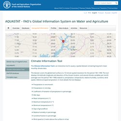
The dataset covers the global land surface at a 10 minute spatial resolution for the period 1961-1990. The tool displays the latitude, longitude and elevation of the chosen location, and several climate variables per month (average over the period 1961-1990) related to: precipitation, temperature, relative humidity, sunshine, wind speed, reference evapotranspiration. In more details the tool displays: Precipitation in mm/monthPrecipitation in mm/dayCoefficient of Variation of precipitation in percentageWet daysMean temperature in °CMaximum temperature in °CMinimum temperature in °CDays of groundfrostRelative humidity in percentageSunshine fraction in percentageWind speed at 2 metre above the surface in m/secReference evapotranspiration in mm/monthReference evapotranspiration in mm/day.
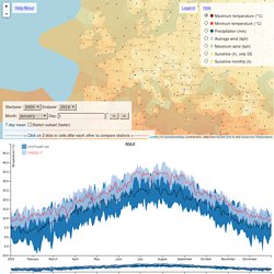
Global weather comparison of cities over time and location. Leaflet | © OpenStreetMap Contributors, data from NOAA GHCN and Deutscher Wetterdienst Choose measurement Hide --------------> Click on 2 dots or cells after each other to compare stations <--------------
Big Ladder Software. Welcome!
Elements is a free, open-source, cross-platform software tool for creating and editing custom weather files for building energy modeling. The goal of the project is to develop a comprehensive, integrated application suitable for handling all of the common tasks associated with weather files. Source code and issue tracker are hosted on our Bitbucket repository. Please help us out with your bug reports and pull requests! Elements was developed by Big Ladder Software with the generous funding and collaboration of Rocky Mountain Institute.
Features Major features include capabilities to: Read/write common weather file formats DOE-2 (.bin, .fmt) EnergyPlus (.epw) Browse/edit weather data Smart spreadsheet editor Automatic preservation of psychrometric and solar relationships Tools for bulk data transformation: offset, scale, normalize Copy and paste to/from Excel File header editor IP or SI units Visualize weather data Dynamic, multi-variable line chart (experimental) Background. Normales et records. IRM - Climat dans votre commune. La protection de votre vie privée et de vos données à caractère personnel est importante à nos yeux.
C’est pourquoi nous voulons, par le biais de cette politique de confidentialité, vous expliquer dans la plus grande transparence les données que nous recueillons auprès de vous, à quelles fins, et ce que nous voulons en faire. Parcourez attentivement cette politique et n’hésitez pas à nous adresser vos questions ou remarques. Cette politique de confidentialité s’applique à tous les services de l'IRM : Les services en ligne de l'IRM : sites web, applications et services internet qui vous donnent accès au contenu de l'IRM ; Tous les autres services avec lesquels vous entrez en contact, tels que les concours, actions SMS, événements… Cette politique de confidentialité relève de la responsabilité de l'IRM, ayant son siège social à Avenue Circulaire 3 à Uccle.
Il est possible que nous soyons amenés à modifier notre politique à certains moments. White Box Technologies Weather Data. Climate Consultant Download Page. Epwmap. Climate.onebuilding.org. Weather Data. Weather data for more than 2100 locations are now available in EnergyPlus weather format — 1042 locations in the USA, 71 locations in Canada, and more than 1000 locations in 100 other countries throughout the world.
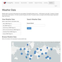
The weather data are arranged by World Meteorological Organization region and Country. View Weather Data Select a region below to view weather data. Browse Weather Data Click on the markers in the map below to access weather data. The Auxiliary Programs document that is packaged with EnergyPlus includes information about weather data in general, the EnergyPlus weather data format, and weather file conversion. Intro - Meteonorm (en) Photovoltaic Geographical Information System (PVGIS) Try the PVGIS tools: PVGIS is available in English, French, Italian and Spanish for any location in Europe and Africa, as well as large part of Asia and America.
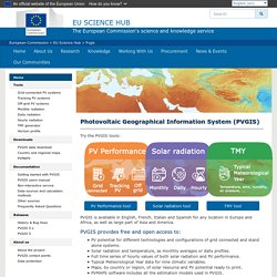
PVGIS provides free and open access to: PV potential for different technologies and configurations of grid connected and stand alone systems. Solar radiation and temperature, as monthly averages or daily profiles. Full time series of hourly values of both solar radiation and PV performance. Map disclaimer The designations employed and the presentation of material on the maps do not imply the expression of any opinion whatsoever on the part of the European Union concerning the legal status of any country, territory, city or area or of its authorities, or concerning the delimitation of its frontiers or boundaries.
Download DView. The Typical Weather Anywhere on Earth - Weather Spark.