
Ninety Mile Beach Accommodation. Whanganui River Canoes. Prohibited or restricted conservation areas: Freedom camping. Alert/Important Notice The following notices have been added: The following notices have been amended:
Northland tapotupotu. 100 Great Peaks of New Zealand. Transaction Centre. 10 Best Day Hikes on the South Island of New Zealand - InAFarawayLand.com. Mount Alfred: Walking and tramping in Glenorchy area. Safer Parking - Secure Parking - Te Anau - Fiordland. Avalanche Forecasts for Backcountry Mountain Regions. Valle volcánico Waimangu, fantástica reserva termal en Rotoura. El valle de Waimangu era, hasta la explosión del año 1886, un valle cubierto por la vegetación pero sin cráteres volcánicos.
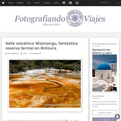
Tras esa explosión, se formaron los diversos cráteres, fumarolas y calderas volcánicas, por lo que es uno de los pocos sitios de este tipo en el que se conoce la edad exacta del lugar. Sorprende ver fotos de esos años, e incluso fotografías antiguas de las principales explosiones. En la visita a Roturua, en la isla norte de Nueva Zelanda, uno se plantea qué reservas volcánicas visitar, ya que la oferta es amplia y todas son de pago.
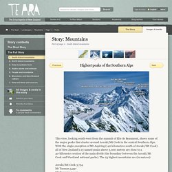
Tanto Wai-O-Tapu (ya te lo contamos en otra entrada) como el Valle Volcánico Waimangu valen cada dólar neozelandés que pagues por la entrada. La visita de Waimangu. Nservation Campsite Pass. Adventure Smart - Outdoor Safety Information & Tips. Mountains. Highest peaks of the Southern Alps – Mountains. This view, looking south-west from the summit of Elie de Beaumont, shows some of the major peaks that cluster around Aoraki/Mt Cook in the central Southern Alps.
NZ 3,000 metre peaks - Occasional Climber. Mt Elie de Beaumont. A visit to Mordor (The Tongariro Northern Circuit) Yep – almost ready to go!
It’s been non-stop for me for the last 48 hours. After wrapping up an intense day at work on Wednesday, there was just no time for pause as I rushed home to face a frantic evening of last minute packing for yet another much anticipated visit to New Zealand (also known to us as “the country we should have moved to”). True to our form, despite messing around with our stuff for several days prior, we were still nowhere near ready, and by the time we had everything in a more or less decent state, it was close to midnight. Our Thursday was essentially a day of travelling, summed up by a 4:30am start, a roughly 1hr cab ride to the airport, a 3 hour flight, a 5.5 hour drive from Wellington to Whakapapa (look up pronunciation!) Village in the Tongariro National Park, followed by some frantic gear organisation in the hotel room.
Five hours later, I snapped awake, well before the alarm went off. Whakapapa Village walking tracks: Walking and tramping in Tongariro National Park, Whakapapa Village area. Ruapehu from Ridge Track Ridge Track Time: 30 - 40 min returnDistance: 1.2 km return Begins 150 metres above Whakapapa Visitor Centre, beside the public shelter.
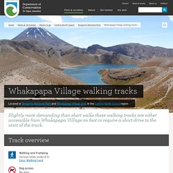
After a short climb through low beech forest, the track emerges into alpine shrublands with panoramic views of Ruapehu, Ngauruhoe and the surrounding landscape. Return via same track. Volcanic risk in Tongariro National Park: Tongariro National Park. Te Maari eruption 21 November 2012 Tongariro National Park is an active volcanic area.
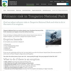
Eruptions from any of the three volcanoes can happen at any time without warning. If you are hiking or climbing within the active volcanic hazard zones when an eruption happens, you could be in danger from eruption hazards. Eruption hazards In an eruption you could be in danger of: Tongariro National Park Visitor Centre: Tongariro National Park activities. The Visitor Centre provides a range of visitor information and services The Tongariro National Park Visitor Centre (historically known as Whakapapa Visitor Centre) is located at Whakapapa Village, the main gateway into Tongariro National Park - New Zealand’s first national park and dual world heritage area.
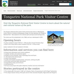
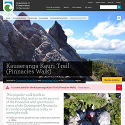
The centre was first established in the 1960s and was redeveloped in 2001. Kauaeranga Kauri Trail (Pinnacles Walk): Walking and tramping in Coromandel Forest Park, Kauaeranga Valley. Walking options Walk to Pinnacles Hut and summit as a day or overnight walkWalk there and back on the Webb Creek Track (6 - 7 hr 30 min) or complete a circuit using the Webb Creek Track and the Billygoat Track ( 8 - 9 hr 30 min)Sample the track and walk the shorter Billygoat Circuit.
Cape Reinga/Te Rerenga Wairua Lighthouse Walk: Walking and tramping in Te Paki Recreation Reserve, Cape Reinga (Te Rerenga Wairua) Description Walk a short distance to the lighthouse to experience outstanding views of our Northern Coast.
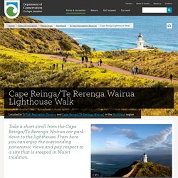
To the west Cape Maria Van Dieman and Motuopao Island, to the east is Piwhane/Spirits Bay and Hikurua/de Serville Cliffs, the North Island's most northern point. Offshore, you can witness the immense power of two mighty oceans merging. The currents of the Tasman Sea and the Pacific Ocean meet in a foaming swell of broken water over the Columbia Bank. At times, the churning waves erupt in explosions of spray and spume. Getting there Cape Reinga/Te Rerenga Wairua is located at the northernmost area of New Zealand, approximately 111 km north of Kaitaia.
Follow State Highway 1 north to Waitiki Landing, continuing another 20 km to Cape Reinga/Te Rerenga Wairua. Cape Reinga Road gets very busy over the summer months. Kepler track. New Zealand's official weather forecasts & warnings - Meteorological Service of New Zealand (MetService) NZ Avalanche Centre, for backcountry advisory and avalanche forecasts.
New Zealand Topographic Map - NZ Topo Map. Plan and prepare - Milford Track. Waipoua Forest: Places to go in Northland. Nature and conservation Waipoua, and the adjoining forests of Mataraua and Waima, make up the largest remaining tract of native forest in Northland.
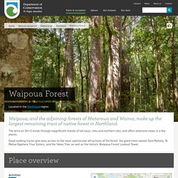
Most of Northland’s ancient forest cover has been lost to saw and fire, plundered for the precious timber of the kauri tree or cleared for farmland. However the forests are now under the protection of the Department of Conservation. Waipoua is home to the kauri, one of the world’s mightiest trees. The largest kauri reach more than 50 metres tall, have trunk girths up to 16 metres, and sprang from seed as long as 2,000 years ago.