
The Facts and Figures about the Power of Visual Content - Infographic We all know that images are compelling. The growth of visual content has been on a rapid upward trajectory over the last 12 months. Social media platforms such as Pinterest and Instagram have taken the social media world by storm. Instagram announced in July that it had acquired 80 million users. Compete.com recently released a report showing that Instagram was the fastest growing web property on the planet amongst the top 50 websites. Simply Measured looked at Facebook’s top 10 brand pages to find out the real numbers and facts and figures on the engagement and sharing levels of photos and videos in comparison to text and discovered: Videos are shared 1,200 percent more than links and text posts combinedPhotos are liked 200% more than text updates To put some perspective on the power of visual content other studies show that Photo and video posts on Pinterest are referring more traffic than Twitter, Stumbleupon, LinkedIn and Google+. It is now available on Amazon. Image by Big Stock Photo
Portail environnement Change the Course [INFOGRAPHIC] Help Save the Colorado River You can help restore freshwater ecosystems by pledging to cut your water footprint. For every pledge, Change the Course will restore 1,000 gallons back to the Colorado River. Text "River" to 77177 or click here: How Star Wars Changed the World Hopefully reading this infographic will give you a nice break, writing about it has for me. I sit here amidst a slew of homework, from writing a paper on Rousseau and his Discourses to studying Chinese Politics. Now after finding this infographic, all I want to do is put everything away and watch Star Wars. Whether you are a fan of the double triology (? Not to lead you on, but this infographic is not so much about the story/plot of Star Wars. Click to enlarge Share This Infographic Get Free Infographics Delivered to your Inbox
Réseau agriculture durable Cette collection a été créée pour que le lecteur trouve rapidement des réponses à des questions cruciales, souvent en prise avec les grands enjeux planétaires. Pour chaque thème, une fiche centrale de 4 ou 6 pages pose la problématique. Elle renferme une dizaine de fiches recto-verso relatant des témoignages d’agriculteurs. Chaque numéro est téléchargeable gratuitement. Pourquoi/comment réduire ma consommation de pesticides à la ferme (2014) Pourquoi/comment réduire ma consommation de pesticides à la ferme (2006) Pourquoi/comment développer le pâturage Pourquoi/comment adapter son système herbager pâturant aux aléas climatiques Pourquoi/comment Aménager sa ferme pour le pâturage tournant Pourquoi/comment préserver ou améliorer la biodiversité à la ferme Pourquoi/comment gérer et valoriser son bocage Pourquoi/comment économiser l’énergie à la ferme Pourquoi/comment développer les énergies renouvelables à la ferme Pourquoi/comment réaliser une mise aux normes économe mais aussi… 79500 Melle
Energy and water resources - IGCSE Geography - Revision guide - TTS LibGuides at Tanglin Trust School Factors Affecting the Selection of Site for Dams 1) Good topographical location along the path of river: The best location along the path of the river is river canyon or at the location where there is narrowing of the river. If the aim is to store maximum amount of water, then the volume of basin above dam should be calculated so that sufficient quantity of water can be stored in it. The perfect site is one where there is wide and flat valley. 2) Right geological structure: The rock structure on which the dam will be constructed should be strong enough to sustain the weight of dam and water stored in the dam. 3) Sufficient water is available: The flow of water where dam is constructed should be sufficient enough to fill the dam. People living around the areas where storage basin is going to be constructed and the areas that will be submerged should be convinced to move from there and they should be given proper compensation and suitable resettlement areas.
Infographics James Bond may be the world's coolest secret agent killing super villains and saving hot babes all while cruising around in his fully modified Aston Martin that he seems to… Everyone has their favorite characters from DC and Marvel and may have even duked it out them out in Street Fighter style Marvel vs DC fighting games but how well… The SOPA bill that threatened to destroy the internet has finally be taken down after a long period of protesting. Just what exactly did it take to make Congress finally… Miss the State of the Union address yesterday or just want to review some of the highlights? I love Big Macs. Think airline services are bad enough and they're just out to get your money? Facebook is the biggest social network in the world. Technology can be a great ally for education -- but how big is its role in the learning process? We often think that scientists are the most honest people around, and assume that scientific findings are reliable and true.
Le Spoutnik illustr? Les jeux olympiques : une vidéo annotée ! Wednesday, 27 January 04:09 pm C’est une fonction avancée de YouTube qui permet d’insérer des commentaires et des liens dans la vidéo. Je m’en suis servi pour commenter cette vidéo disponible sur le site du Comité international olympique (CIO). L’aventure d’un scribe en Mésopotamie Tuesday, 10 November 12:15 pm Nous avons regardé cette vidéo en classe. Une vidéo du Grenelle de l’environnement très géographique Thursday, 24 September 09:29 pm Ce film publicitaire du Grenelle de l’environnement intervient près de deux ans après les conclusions du Grenelle : « Deux ans après les conclusions du Grenelle Environnement, au lendemain du vote solennel au parlement de la loi Grenelle 1, et alors que débute au Sénat la loi Grenelle 2, le Ministère lance une campagne de communication afin de sensibiliser les Français sur toutes ces avancées. » Cette vidéo est très pédagogique et très géographique : on pourrait dire pédagéogique ! Thursday, 24 September 03:25 pm
Coast fieldwork Search Geographical enquiry Rivers Coast Urban Rural Ice Ecology Coastal fieldwork Low energy coasts Investigating low energy coasts - beach profiling and sediment analysis High energy coasts Investigating high energy coasts - cliffs, wave-cut platforms and headlands Coastal management Investigating the methods, impacts and perception of coastal management Looking for a next step? Copyright © 2010 Field Studies Council Creative Commons Attribution-Noncommercial-No Derivative Works 3.0 Licence . FEEDBACK Do you have any questions?
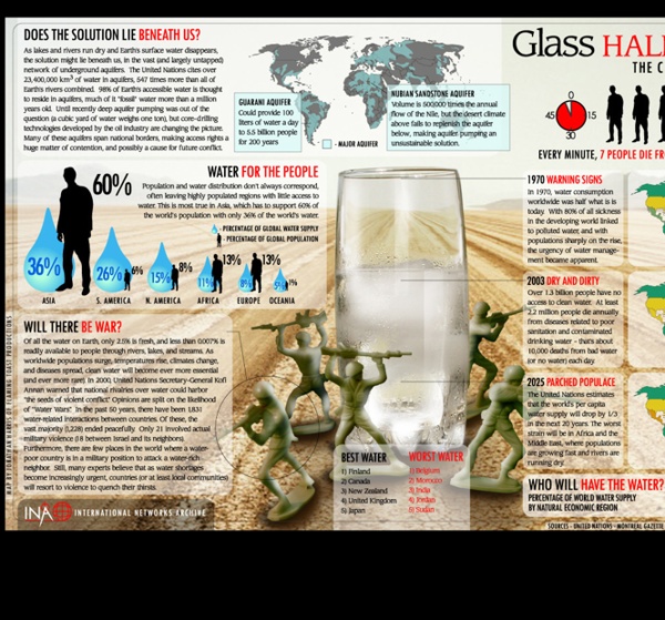
The Quest to Power Africa More Infographics on Good Terretv - La télé web des générations futures