
How to Add Annotations to YouTube Videos. Kodotchigova - Role Play in Teaching Culture: Six Quick Steps for Classroom Implementation. The Internet TESL Journal Maria A.

Kodotchigovamashamaria2001 [at] yahoo.comTomsk State University, Russia An extended version of this paper first appeared in:Sysoyev, P.V. (Ed.). (2002). Identity, Culture, and Language Teaching. Immersive learning technologies: Realism and online authentic learning. Learning on the Holodeck. Immersive Learning Environments (ILEs) - Gartner IT Glossary. - LANNY SORENSON: LEARNING SIMULATIONS ADD TO CLASSROOM LESSONS - Teachers.Net Gazette - MENTORING, STRESS RELIEF, STUDENT MOTIVATION, ORGANIZATION IDEAS, CLASSROOM MANAGEMENT, LESSON PLANS, DISCIPLINE, AND MORE - featuring columns and articles by top nam.
Teacher Feature...

Learning Simulations Add to Classroom Lessons. Journey Into Amazonia. Related National Standards Grade Level: 5-9 Estimated Time: One class period to watch each of the videos, though a single video will allow students to see a variety of trees.

One class period to construct a broom tree and sketch the different support systems. Overview In this lesson, students will better understand that the environmental factors of an area affect a species's characteristics over time. The shallow, nutrient-poor nature of the soil in the Amazon basin has caused many trees to have rapid growth as they seek sunlight, and also develop interesting support strategies to hold the top-heavy trees without using taproots. Duke immersive Virtual Environment. The IEEE Virtual Reality Conference is the premier meeting on its topic and this year it will be held in Greenville, SC featuring recent developments in virtual reality technology with the attendance of academics, researchers, industry representatives, and VR enthusiasts.

Our own David Zielinski will be representing Duke to present his recent paper, “Evaluating the Effects of Image Persistence on Dynamic Target Acquisition in Low Frame Rate Virtual Environments,” co-authored with Hrishikesh Rao, Nick Potter, Marc Sommer, Lawrence Appelbaum, and Regis Kopper in the IEEE Symposium on 3D User Interfaces, co-located with the Virtual Reality conference.
Seguridad en los Juegos Olímpicos de Río 2016. Microsoft Cognitive Services - Bing Video Search API. Seguridad Diplomatica - Bing video. United States Department of State. Putting video on the map - Create your own video with a map. Cultural mapping initiative seeks to strengthen city’s identity. There might be a violinist in the middle of the mall or pan dulce at the symphony concert.

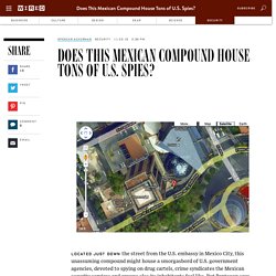
Putting video on the map - Create your own video with a map. Does This Mexican Compound House Tons of U.S. Spies? Located just down the street from the U.S. embassy in Mexico City, this unassuming compound might house a smorgasbord of U.S. government agencies, devoted to spying on drug cartels, crime syndicates the Mexican security services and anyone else its inhabitants feel like.

U.S. Super Intelligence Center Revealed in Mexico. By: Jorge Carrasco A. and J.

Jesús Esquivel Proceso With the approval of Felipe Calderón’s Administration, the U.S. Government finally got what it always wanted: To set up a super spy center in Mexico City. It was the escalation of the drug war in the country what opened the door to all U.S. intelligence agencies, including the military, to operate out of the Federal District without having to disguise their agents as diplomats. Spreading Wings S900 : un système de prises de vue aériennes très léger et puissant destiné aux réalisateurs exigeants.
How Mexico is becoming the drone capital of Latin America. Mexico is getting high on drones.

A lack of strict aerospace regulations combined with a growing manufacturing and aerospace industry could turn the country into the drone capital of Latin America. Mexico recently opened the first drone pilot academy in region, and now hopes to become a global competitor in the high-flying industry. “We saw a wave of consumers buying drones, but they didn’t know how to operate them,” Jose Luis Gonzalez, director of Mexico’s Drone Academy and CEO of Unmanned Systems, told Fusion.
Tutorial sobre Drone para Fotografía y Video. Si estás decidido a equiparte con un dron para dedicarlo a filmación de video y fotografía lo primero que tendrías que decidir es la calidad en la que quieres obtener las imágenes: varios drones semi-profesionales disponibles en el mercado montan de serie cámaras con resolución hasta 4K y te dan la opción de que el piloto maneje el RPA y el operador de cámara se ocupe del manejo de ésta independientemente; los precios son más económicos comparados con equipos realmente profesionales, pero normalmente están limitados a las características que ofrecen cuando los compras, es decir, si pasado un tiempo la tecnología avanza, que lo hará sin duda, tu RPA semi-profesional se quedará obsoleto, y seguramente habrá sido barato, pero ¿te habrá resultado rentable?

Si te decides por un RPA profesional el cual monte la cámara que tú quieras, tendrás que tener en cuenta varios aspectos técnicos: Dronefilms.co - Filmación aérea con drones. Assessment Tasks : Classroom : CGTL, FDU. World Languages Assessment Tasks World Languages Resources for K-12 Teachers and Parents Some helpful information . . .

Users of the assessment materials developed during the Central Jersey World Languages Professional Development Project will find a departure from traditional foreign language assessment, and, hopefully, that will be a happy discovery. The entire purpose of the myriad tasks found in this section is to provide foreign language educators with options in how they assess their students. Let's be honest . . . Over the past 20 years, massive changes have occurred in the way students are taught foreign languages yet little change has been observed in assessing student progress.
Language-Learning Simulations: A Practical Guide. Drones para evitar robos. DJI reschedules its drones to prevent flying over sensitive areas. GPS DJI drones detected entering a sensitive area for security reasons, it will warn the user and in some cases divert your route. Thus, prevent computers are flying over stadiums and other sports facilities, airports, embassies and civilian and military areas. Coinciding with the terrorist alert that exists these days, DJI, one of the leading manufacturers of drones, It has announced that it will reschedule its aircraft to avoid flying over sensitive areas.
With this update, GPS detect the drone entering a prohibited area and, by level of alert, it will warn the user or directly divert the path of the apparatus. in the latter case, the user may request a temporary release of this restriction in certain areas, while in other cases you can not get the restriction. The Chinese manufacturer overflying prevent their teams stadiums and other sports facilities, airports, embassies and civilian and military sensitive areas around the world that are available in this site. Spanish regulation.
Volando sobre la Ciudad de México en Drone. 243269. Bureau of Diplomatic Security. The year 2016 marks a century since Secretary of State Robert Lansing appointed the U.S. Department of State’s first special agents as part of World War I-era security measures. Today, the men and women of the Diplomatic Security Service (DSS) continue their work as part of a global force providing a safe and secure environment for the conduct of U.S. foreign policy. Volando sobre la Ciudad de México en Drone. Santa Fe, Ciudad de Mexico (vuelo en drone) - Up In The Sky. First tests with md4-1000 and Z15 - 2,5KG PAYLOAD! Crímenes de alto impacto. Zocalo. El Caballito. El Caballito The famous bronze equestrian statue of Charles IV of Spain, popularly known as "El Caballito" (the "Little Horse"); also by Manuel Tolsá, it was modelled on a statue by the French sculptor Girardon.
The statue originally stood on the Zócalo, but after independence it was moved to various places in the city before finally ending up at its present site. El Caballito is located between the National Art Museum and the Palacio de Minería. The National Art Museum. View of Mexico city from Santa Fe. GigaPan Stitch version 1.0.0805 (Windows) Panorama size: 6057 megapixels (131248 x 46152 pixels) Input images: 720 (36 columns by 20 rows) Field of view: 131.9 degrees wide by 46.4 degrees high (top=9.3, bottom=-37.1) Settings: All default settings Original image properties: Camera make: Canon Camera model: Canon EOS 7D Image size: 5184x3456 (17.9 megapixels) Capture time: 2011-01-16 13:03:33 - 2011-01-16 13:50:32 Aperture: f/6.3 Exposure time: 0.001 ISO: 100 Focal length (35mm equiv.): 392.6 mm White balance: Fixed Exposure mode: Manual Horizontal overlap: 29.2 to 44.2 percent Vertical overlap: 32.0 to 36.9 percent Computer stats: 3061.97 MB RAM, 2 CPUs Total time 2:13:41 (11 seconds per picture) Alignment: 44:57, Projection: 11:28, Blending: 1:17:17 (Preview finished in 1:14:14)
Jeopardy Rocks - Jeopardy Game Creator For Teachers. Frida kahlo - Institut culturel de Google. NBC News Interactive Newsroom. Newseum - Be a TV Reporter. Museums of the World Reviews. An Apple Virtual field trip selection. GeoSettr - Create your own GeoGuessr challenge. Simulations And Games: Making Learning Fun!