

Ergebnis für. Ergebnis für. The Welsh Piper » Arr-Kelaan Hexmapper. A fast and easy tool for making old-school hex maps Hex map authors have always enjoyed their ability to quickly create vast tracts of land simply by applying a terrain icon to a blank hex.
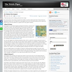
Hex World » Map. 3D Map Creation The various 3D battlefields were achieved as follows: Create Heightmap This can be achieved using several methods.

For historic maps you have a choice of using old maps that could contain survey errors versus using modern maps that are accurate, but don’t account for any terrain changes. For example the Waterloo battle field was dramatically “sculptured” building the Lion Mound in 1826, and the more recent building of modern roads. I traced out the contour detail and then assigned a greyscale value to each of the contour heights.
Although I started with a 2048 x 2048 pixel map, which covered an area 5Km x 5Km it was obvious that the resulting mesh would be to great (for the XBox). The terrain mesh was to be created from the heightmap and so a Content Processor was required to create the mesh. So my final map model represents an area 5.120 Km wide x 3.83 Km deep, which covers all the significant areas of the Waterloo battlefield. To be continued…. Ergebnis für. Ergebnis für. Rts - Tweaking Heightmap Generation For Hexagon Grids. Random Terrain Generator. I mentioned in a recent post that I was working on a set of random tables for terrain generation.
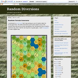
The tables themselves aren't quite ready for use; at the moment they only exist as an Excel spreadsheet; but I did spend an hour to build a small test map. Once I had the raw map done on graph paper, I used Hexographer to create a legible map. It's not too bad actually. I still have some work to do, mostly with how the tables are selected and how coastal / ocean areas are generated.
Right now oceans tend to fill all available space. The Welsh Piper » Hex-based Campaign Design (Part 1) Campaign Design by the Hex deutsche Übersetzung In my quest for rapid campaign development, I came across an elegant idea called Six sided gaming: Hex magic on Greywulf’s Microlite d20 site.

Subtitled “the lazy gamer’s guide to world building,” Six sided gaming suggests launching your campaign with an adventure in a single hex, then placing adventures in each of the six surrounding hexes, assigning hex terrain and encounters to match the adventures you’ve chosen. As the campaign grows, you simply populate the next “ring” of surrounding hexes, and so on and so on. Defining the campaign by its adventures—instead of the other way round—is a great time-saver and perfect for the busy GM. Skip to Part 2… The Welsh Piper » Hex-based Campaign Design (Part 1) The Word of Notch — Terrain generation, Part 1. Welcome - Procedural Content Generation Wiki.
Biome. Different biomes Ecoregions are grouped into both biomes and ecozones.
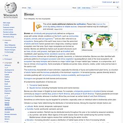
A fundamental classification of biomes are: Terrestrial (land) biomesAquatic biomes (including freshwater biomes and marine biomes) Biomes are often known in English by local names. For example, a temperate grassland or shrubland biome is known commonly as steppe in central Asia, prairie in North America, and pampas in South America. Sometimes an entire biome may be targeted for protection, especially under an individual nation's biodiversity action plan.
Climate is a major factor determining the distribution of terrestrial biomes. The most widely used systems of classifying biomes correspond to latitude (or temperature zoning) and humidity. Biome classification schemes[edit] The distribution of vegetation types as a function of mean annual temperature and precipitation. Dungeon League. Polygonal Map Generation for Games. I wanted to generate interesting game maps that weren’t constrained to be realistic, and I wanted to try some techniques I hadn’t tried before.
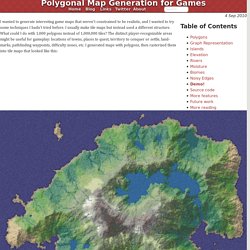
I usually make tile maps but instead used a different structure. What could I do with 1,000 polygons instead of 1,000,000 tiles? The distinct player-recognizable areas might be useful for gameplay: locations of towns, places to quest, territory to conquer or settle, landmarks, pathfinding waypoints, difficulty zones, etc. I generated maps with polygons, then rasterized them into tile maps that looked like this: Most procedural map generators, including some of my own previous projects, use noise functions (midpoint displacement, fractal, diamond-square, perlin noise, etc.) to generate a height map.
There were three main things I wanted for this project: good coastlines, mountains, and rivers. First, try the demo! Every project will have its own gameplay constraints. Polygons The first step is to generate some polygons. Timetocode, Volcanic Map Generation Step by Step. Map Generator source code is available now! So I just noticed I haven’t even opened the map generator project for a looong time so decided to open-source it instead of just letting it rot on my hdd.
I mean why not, right? -What is this? Blog posts about this project; Part 1 - Introduction Part 2 - Creating the Island Part 2.5 - Smoothing the Coastline.